You are here: Home > Network List > KN - Kyrgyz Seismic Telemetry Network Stations List
> Station EKS2 KN.EKS2 > Earthquake Result Viewer
EKS2 KN.EKS2 - Earthquake Result Viewer
| Earthquake location: |
Kuril Islands |
| Earthquake latitude/longitude: |
44.6/149.4 |
| Earthquake time(UTC): |
1995/12/03 (337) 18:01:08 GMT |
| Earthquake Depth: |
33 km |
| Earthquake Magnitude: |
6.6 MB, 8.0 MS |
| Earthquake Catalog/Contributor: |
WHDF/NEIC |
|
| Network: |
KN Kyrgyz Seismic Telemetry Network |
| Station: |
EKS2 KN.EKS2 |
| Lat/Lon: |
42.66 N/73.78 E |
| Elevation: |
1360 m |
|
| Distance: |
52.9 deg |
| Az: |
296.377 deg |
| Baz: |
60.241 deg |
| Ray Param: |
0.06640428 |
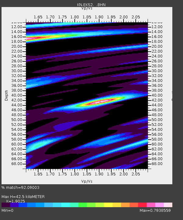
| Estimated Moho Depth: |
42.5 km |
| Estimated Crust Vp/Vs: |
1.90 |
| Assumed Crust Vp: |
6.316 km/s |
| Estimated Crust Vs: |
3.32 km/s |
| Estimated Crust Poisson's Ratio: |
0.31 |
|
| Radial Match: |
92.09003 % |
| Radial Bump: |
400 |
| Transverse Match: |
86.248146 % |
| Transverse Bump: |
400 |
| SOD ConfigId: |
6273 |
| Insert Time: |
2010-03-08 19:49:12.125 +0000 |
| GWidth: |
2.5 |
| Max Bumps: |
400 |
| Tol: |
0.001 |
|

Signal To Noise
| Channel | StoN | STA | LTA |
| KN:EKS2: :BHN:19951203T18:09:50.575012Z | 3.0919175 | 5.485212E-7 | 1.7740487E-7 |
| KN:EKS2: :BHE:19951203T18:09:50.575012Z | 5.9119797 | 9.057629E-7 | 1.5320805E-7 |
| KN:EKS2: :BHZ:19951203T18:09:50.575012Z | 9.609389 | 2.235052E-6 | 2.3259045E-7 |
| Arrivals |
| Ps | 6.4 SECOND |
| PpPs | 19 SECOND |
| PsPs/PpSs | 25 SECOND |


