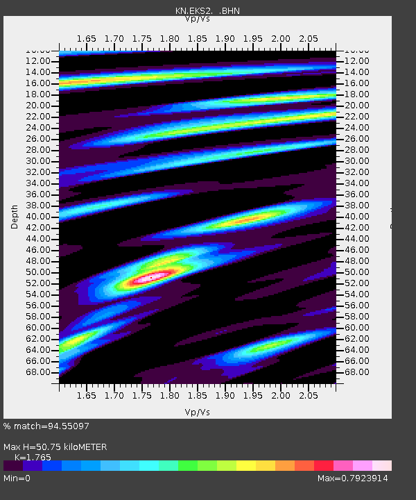
EKS2 KN.EKS2 - Earthquake Result Viewer
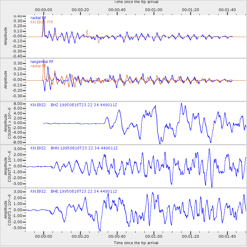
Earthquake location: Solomon Islands
Earthquake latitude/longitude: -5.8/154.3
Earthquake time(UTC): 1995/08/16 (228) 23:10:28 GMT
Earthquake Depth: 74 km
Earthquake Magnitude: 6.1 MB, 7.2 MS, 7.2 UNKNOWN, 7.2 MW
Earthquake Catalog/Contributor: WHDF/NEIC
Network: KN Kyrgyz Seismic Telemetry Network
Station: EKS2 KN.EKS2
Lat/Lon: 42.66 N/73.78 E
Elevation: 1360 m
Distance: 86.9 deg
Az: 313.237 deg
Baz: 100.674 deg
Ray Param: 0.043559432
Estimated Moho Depth: 50.75 km
Estimated Crust Vp/Vs: 1.76
Assumed Crust Vp: 6.316 km/s
Estimated Crust Vs: 3.578 km/s
Estimated Crust Poisson's Ratio: 0.26
Radial Match: 94.55097 %
Radial Bump: 400
Transverse Match: 88.08685 %
Transverse Bump: 400
SOD ConfigId: 6273
Insert Time: 2010-03-08 19:49:18.354 +0000
GWidth: 2.5
Max Bumps: 400
Tol: 0.001

Signal To Noise

ChannelStoNSTALTA
KN:EKS2: :BHN:19950816T23:22:34.449011Z1.35165456.622924E-84.899865E-8
KN:EKS2: :BHE:19950816T23:22:34.449011Z4.02871752.4605035E-76.107412E-8
KN:EKS2: :BHZ:19950816T23:22:34.449011Z10.2456191.0480625E-61.02293725E-7
Arrivals
Ps6.3 SECOND
PpPs22 SECOND
PsPs/PpSs28 SECOND