You are here: Home > Network List > TA - USArray Transportable Network (new EarthScope stations) Stations List
> Station D25K Kavik River, AK, USA > Earthquake Result Viewer
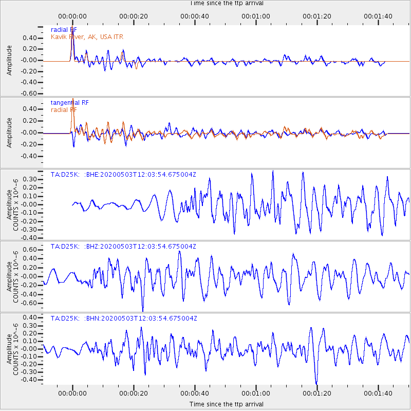
D25K Kavik River, AK, USA - Earthquake Result Viewer
*The percent match for this event was below the threshold and hence no stack was calculated.
| Earthquake location: |
Northwest Of Ryukyu Islands |
| Earthquake latitude/longitude: |
31.4/128.8 |
| Earthquake time(UTC): |
2020/05/03 (124) 11:54:24 GMT |
| Earthquake Depth: |
10 km |
| Earthquake Magnitude: |
5.9 mww |
| Earthquake Catalog/Contributor: |
NEIC PDE/us |
|
| Network: |
TA USArray Transportable Network (new EarthScope stations) |
| Station: |
D25K Kavik River, AK, USA |
| Lat/Lon: |
69.32 N/146.38 W |
| Elevation: |
770 m |
|
| Distance: |
59.2 deg |
| Az: |
24.327 deg |
| Baz: |
277.488 deg |
| Ray Param: |
$rayparam |
*The percent match for this event was below the threshold and hence was not used in the summary stack. |
|
| Radial Match: |
74.08079 % |
| Radial Bump: |
400 |
| Transverse Match: |
66.587326 % |
| Transverse Bump: |
400 |
| SOD ConfigId: |
21166931 |
| Insert Time: |
2020-05-17 12:05:42.428 +0000 |
| GWidth: |
2.5 |
| Max Bumps: |
400 |
| Tol: |
0.001 |
|
Signal To Noise
| Channel | StoN | STA | LTA |
| TA:D25K: :BHZ:20200503T12:03:54.675004Z | 1.0556653 | 9.56469E-8 | 9.0603436E-8 |
| TA:D25K: :BHN:20200503T12:03:54.675004Z | 0.8047816 | 5.1831037E-8 | 6.440386E-8 |
| TA:D25K: :BHE:20200503T12:03:54.675004Z | 3.8700135 | 1.389449E-7 | 3.590295E-8 |
| Arrivals |
| Ps | |
| PpPs | |
| PsPs/PpSs | |


