You are here: Home > Network List > US - United States National Seismic Network Stations List
> Station LAO LASA Array, Montana, USA > Earthquake Result Viewer
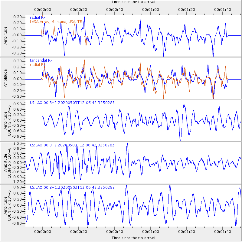
LAO LASA Array, Montana, USA - Earthquake Result Viewer
*The percent match for this event was below the threshold and hence no stack was calculated.
| Earthquake location: |
Northwest Of Ryukyu Islands |
| Earthquake latitude/longitude: |
31.4/128.8 |
| Earthquake time(UTC): |
2020/05/03 (124) 11:54:24 GMT |
| Earthquake Depth: |
10 km |
| Earthquake Magnitude: |
5.9 mww |
| Earthquake Catalog/Contributor: |
NEIC PDE/us |
|
| Network: |
US United States National Seismic Network |
| Station: |
LAO LASA Array, Montana, USA |
| Lat/Lon: |
46.69 N/106.22 W |
| Elevation: |
902 m |
|
| Distance: |
87.8 deg |
| Az: |
34.377 deg |
| Baz: |
315.477 deg |
| Ray Param: |
$rayparam |
*The percent match for this event was below the threshold and hence was not used in the summary stack. |
|
| Radial Match: |
57.94637 % |
| Radial Bump: |
400 |
| Transverse Match: |
64.63972 % |
| Transverse Bump: |
400 |
| SOD ConfigId: |
21166931 |
| Insert Time: |
2020-05-17 12:07:09.628 +0000 |
| GWidth: |
2.5 |
| Max Bumps: |
400 |
| Tol: |
0.001 |
|
Signal To Noise
| Channel | StoN | STA | LTA |
| US:LAO:00:BHZ:20200503T12:06:42.325028Z | 2.214503 | 5.2563814E-7 | 2.3736165E-7 |
| US:LAO:00:BH1:20200503T12:06:42.325028Z | 0.49767432 | 2.5468486E-7 | 5.1175005E-7 |
| US:LAO:00:BH2:20200503T12:06:42.325028Z | 0.64111054 | 2.3619619E-7 | 3.6841723E-7 |
| Arrivals |
| Ps | |
| PpPs | |
| PsPs/PpSs | |


