You are here: Home > Network List > US - United States National Seismic Network Stations List
> Station NEW Newport, Washington, USA > Earthquake Result Viewer
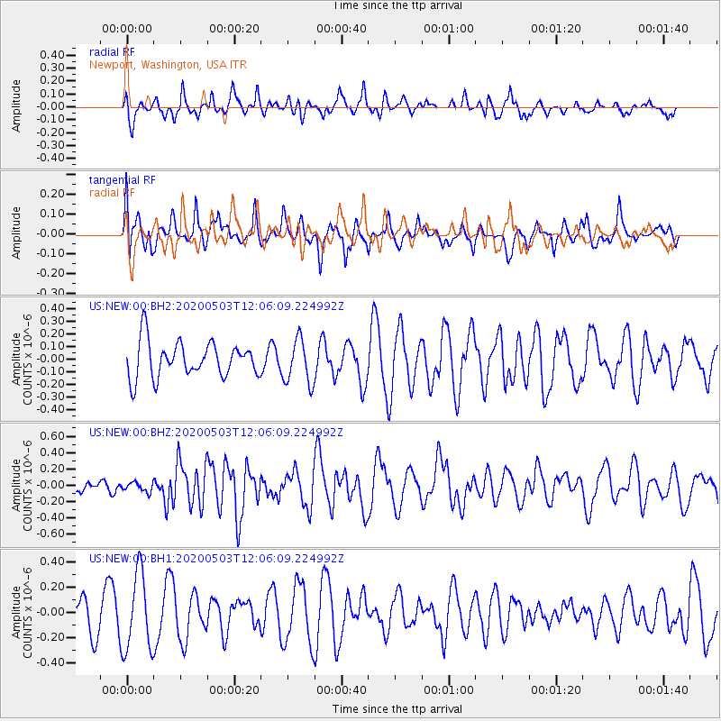
NEW Newport, Washington, USA - Earthquake Result Viewer
*The percent match for this event was below the threshold and hence no stack was calculated.
| Earthquake location: |
Northwest Of Ryukyu Islands |
| Earthquake latitude/longitude: |
31.4/128.8 |
| Earthquake time(UTC): |
2020/05/03 (124) 11:54:24 GMT |
| Earthquake Depth: |
10 km |
| Earthquake Magnitude: |
5.9 mww |
| Earthquake Catalog/Contributor: |
NEIC PDE/us |
|
| Network: |
US United States National Seismic Network |
| Station: |
NEW Newport, Washington, USA |
| Lat/Lon: |
48.26 N/117.12 W |
| Elevation: |
760 m |
|
| Distance: |
81.2 deg |
| Az: |
38.128 deg |
| Baz: |
307.82 deg |
| Ray Param: |
$rayparam |
*The percent match for this event was below the threshold and hence was not used in the summary stack. |
|
| Radial Match: |
48.5802 % |
| Radial Bump: |
400 |
| Transverse Match: |
38.626034 % |
| Transverse Bump: |
359 |
| SOD ConfigId: |
21166931 |
| Insert Time: |
2020-05-17 12:07:11.417 +0000 |
| GWidth: |
2.5 |
| Max Bumps: |
400 |
| Tol: |
0.001 |
|
Signal To Noise
| Channel | StoN | STA | LTA |
| US:NEW:00:BHZ:20200503T12:06:09.224992Z | 0.47953483 | 5.7943588E-8 | 1.2083291E-7 |
| US:NEW:00:BH1:20200503T12:06:09.224992Z | 2.1528823 | 3.083856E-7 | 1.4324313E-7 |
| US:NEW:00:BH2:20200503T12:06:09.224992Z | 1.262119 | 1.7683968E-7 | 1.4011331E-7 |
| Arrivals |
| Ps | |
| PpPs | |
| PsPs/PpSs | |


