You are here: Home > Network List > UU - University of Utah Regional Network Stations List
> Station CCUT Cedar City, UT, USA > Earthquake Result Viewer
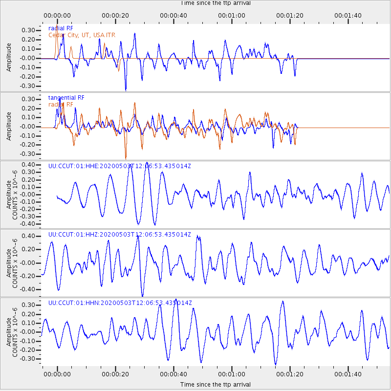
CCUT Cedar City, UT, USA - Earthquake Result Viewer
*The percent match for this event was below the threshold and hence no stack was calculated.
| Earthquake location: |
Northwest Of Ryukyu Islands |
| Earthquake latitude/longitude: |
31.4/128.8 |
| Earthquake time(UTC): |
2020/05/03 (124) 11:54:24 GMT |
| Earthquake Depth: |
10 km |
| Earthquake Magnitude: |
5.9 mww |
| Earthquake Catalog/Contributor: |
NEIC PDE/us |
|
| Network: |
UU University of Utah Regional Network |
| Station: |
CCUT Cedar City, UT, USA |
| Lat/Lon: |
37.55 N/113.36 W |
| Elevation: |
2127 m |
|
| Distance: |
90.1 deg |
| Az: |
44.664 deg |
| Baz: |
310.877 deg |
| Ray Param: |
$rayparam |
*The percent match for this event was below the threshold and hence was not used in the summary stack. |
|
| Radial Match: |
70.018776 % |
| Radial Bump: |
400 |
| Transverse Match: |
50.114445 % |
| Transverse Bump: |
344 |
| SOD ConfigId: |
21166931 |
| Insert Time: |
2020-05-17 12:07:18.337 +0000 |
| GWidth: |
2.5 |
| Max Bumps: |
400 |
| Tol: |
0.001 |
|
Signal To Noise
| Channel | StoN | STA | LTA |
| UU:CCUT:01:HHZ:20200503T12:06:53.435014Z | 1.1910027 | 2.1969E-7 | 1.8445802E-7 |
| UU:CCUT:01:HHN:20200503T12:06:53.435014Z | 0.76982844 | 9.9142305E-8 | 1.2878493E-7 |
| UU:CCUT:01:HHE:20200503T12:06:53.435014Z | 1.9234114 | 2.8744734E-7 | 1.4944662E-7 |
| Arrivals |
| Ps | |
| PpPs | |
| PsPs/PpSs | |


