You are here: Home > Network List > TS - TERRAscope (Southern California Seismic Network) Stations List
> Station SBC Santa Barbara, California, USA > Earthquake Result Viewer
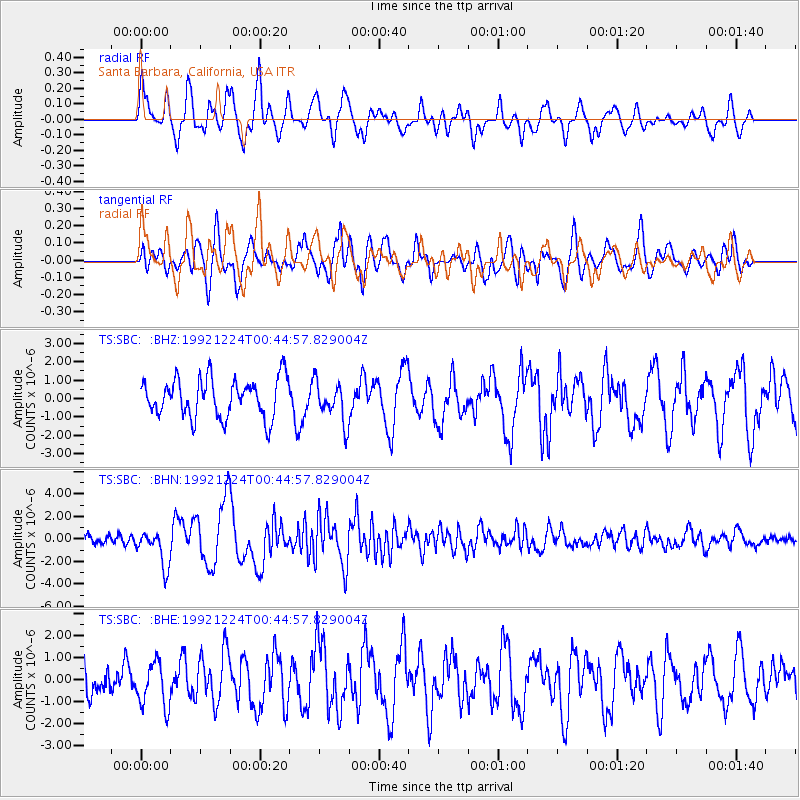
SBC Santa Barbara, California, USA - Earthquake Result Viewer
*The percent match for this event was below the threshold and hence no stack was calculated.
| Earthquake location: |
Tonga Islands |
| Earthquake latitude/longitude: |
-15.3/-173.1 |
| Earthquake time(UTC): |
1992/12/24 (359) 00:34:19 GMT |
| Earthquake Depth: |
68 km |
| Earthquake Magnitude: |
5.8 MB |
| Earthquake Catalog/Contributor: |
WHDF/NEIC |
|
| Network: |
TS TERRAscope (Southern California Seismic Network) |
| Station: |
SBC Santa Barbara, California, USA |
| Lat/Lon: |
34.44 N/119.71 W |
| Elevation: |
90 m |
|
| Distance: |
70.9 deg |
| Az: |
44.614 deg |
| Baz: |
235.093 deg |
| Ray Param: |
$rayparam |
*The percent match for this event was below the threshold and hence was not used in the summary stack. |
|
| Radial Match: |
67.72143 % |
| Radial Bump: |
400 |
| Transverse Match: |
70.42686 % |
| Transverse Bump: |
400 |
| SOD ConfigId: |
4480 |
| Insert Time: |
2010-02-26 14:49:23.886 +0000 |
| GWidth: |
2.5 |
| Max Bumps: |
400 |
| Tol: |
0.001 |
|
Signal To Noise
| Channel | StoN | STA | LTA |
| TS:SBC: :BHN:19921224T00:44:57.829004Z | 4.301028 | 1.615876E-6 | 3.7569532E-7 |
| TS:SBC: :BHE:19921224T00:44:57.829004Z | 1.6667103 | 1.0223101E-6 | 6.1337005E-7 |
| TS:SBC: :BHZ:19921224T00:44:57.829004Z | 1.0528855 | 1.1031024E-6 | 1.0476945E-6 |
| Arrivals |
| Ps | |
| PpPs | |
| PsPs/PpSs | |


