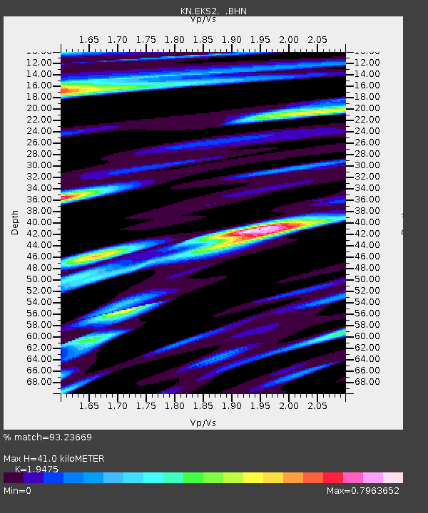
EKS2 KN.EKS2 - Earthquake Result Viewer

Earthquake location: Kuril Islands
Earthquake latitude/longitude: 43.7/147.6
Earthquake time(UTC): 1996/05/07 (128) 23:20:00 GMT
Earthquake Depth: 54 km
Earthquake Magnitude: 6.2 MB, 5.6 MS, 6.2 UNKNOWN, 5.2 MS
Earthquake Catalog/Contributor: WHDF/NEIC
Network: KN Kyrgyz Seismic Telemetry Network
Station: EKS2 KN.EKS2
Lat/Lon: 42.66 N/73.78 E
Elevation: 1360 m
Distance: 52.1 deg
Az: 296.174 deg
Baz: 61.923 deg
Ray Param: 0.06681989
Estimated Moho Depth: 41.0 km
Estimated Crust Vp/Vs: 1.95
Assumed Crust Vp: 6.316 km/s
Estimated Crust Vs: 3.243 km/s
Estimated Crust Poisson's Ratio: 0.32
Radial Match: 93.23669 %
Radial Bump: 400
Transverse Match: 87.132484 %
Transverse Bump: 400
SOD ConfigId: 6273
Insert Time: 2010-03-08 19:50:08.560 +0000
GWidth: 2.5
Max Bumps: 400
Tol: 0.001

Signal To Noise

ChannelStoNSTALTA
KN:EKS2: :BHN:19960507T23:28:34.875024Z9.5577965.2443283E-75.4869645E-8
KN:EKS2: :BHE:19960507T23:28:34.875024Z12.9940346.305637E-74.8527173E-8
KN:EKS2: :BHZ:19960507T23:28:34.875024Z23.6333391.6248118E-66.8750836E-8
Arrivals
Ps6.5 SECOND
PpPs18 SECOND
PsPs/PpSs25 SECOND