You are here: Home > Network List > US - United States National Seismic Network Stations List
> Station WMOK Wichita Mountains, Oklahoma, USA > Earthquake Result Viewer
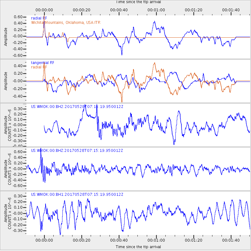
WMOK Wichita Mountains, Oklahoma, USA - Earthquake Result Viewer
*The percent match for this event was below the threshold and hence no stack was calculated.
| Earthquake location: |
Andreanof Islands, Aleutian Is. |
| Earthquake latitude/longitude: |
51.6/-175.3 |
| Earthquake time(UTC): |
2017/05/28 (148) 07:06:14 GMT |
| Earthquake Depth: |
8.0 km |
| Earthquake Magnitude: |
5.6 Ml |
| Earthquake Catalog/Contributor: |
NEIC PDE/at |
|
| Network: |
US United States National Seismic Network |
| Station: |
WMOK Wichita Mountains, Oklahoma, USA |
| Lat/Lon: |
34.74 N/98.78 W |
| Elevation: |
486 m |
|
| Distance: |
55.7 deg |
| Az: |
75.714 deg |
| Baz: |
312.752 deg |
| Ray Param: |
$rayparam |
*The percent match for this event was below the threshold and hence was not used in the summary stack. |
|
| Radial Match: |
48.41775 % |
| Radial Bump: |
400 |
| Transverse Match: |
23.388628 % |
| Transverse Bump: |
400 |
| SOD ConfigId: |
2028011 |
| Insert Time: |
2017-06-11 07:14:00.929 +0000 |
| GWidth: |
2.5 |
| Max Bumps: |
400 |
| Tol: |
0.001 |
|
Signal To Noise
| Channel | StoN | STA | LTA |
| US:WMOK:00:BHZ:20170528T07:15:19.950012Z | 2.4357913 | 1.884017E-7 | 7.7347224E-8 |
| US:WMOK:00:BH1:20170528T07:15:19.950012Z | 0.8604508 | 9.0270234E-8 | 1.049104E-7 |
| US:WMOK:00:BH2:20170528T07:15:19.950012Z | 0.69771236 | 1.03264284E-7 | 1.4800409E-7 |
| Arrivals |
| Ps | |
| PpPs | |
| PsPs/PpSs | |


