You are here: Home > Network List > MM - Myanmar National Seismic Network Stations List
> Station NGU Ngaung U, Myanmar > Earthquake Result Viewer
NGU Ngaung U, Myanmar - Earthquake Result Viewer
| Earthquake location: |
Near East Coast Of Honshu, Japan |
| Earthquake latitude/longitude: |
35.7/140.9 |
| Earthquake time(UTC): |
2020/05/04 (125) 13:07:48 GMT |
| Earthquake Depth: |
41 km |
| Earthquake Magnitude: |
5.6 Mww |
| Earthquake Catalog/Contributor: |
NEIC PDE/us |
|
| Network: |
MM Myanmar National Seismic Network |
| Station: |
NGU Ngaung U, Myanmar |
| Lat/Lon: |
21.21 N/94.92 E |
| Elevation: |
70 m |
|
| Distance: |
42.5 deg |
| Az: |
262.887 deg |
| Baz: |
59.978 deg |
| Ray Param: |
0.073022544 |
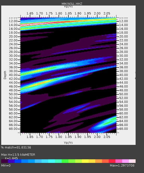
| Estimated Moho Depth: |
13.5 km |
| Estimated Crust Vp/Vs: |
1.64 |
| Assumed Crust Vp: |
6.036 km/s |
| Estimated Crust Vs: |
3.67 km/s |
| Estimated Crust Poisson's Ratio: |
0.21 |
|
| Radial Match: |
81.83136 % |
| Radial Bump: |
400 |
| Transverse Match: |
71.65401 % |
| Transverse Bump: |
400 |
| SOD ConfigId: |
21166931 |
| Insert Time: |
2020-05-18 13:18:16.027 +0000 |
| GWidth: |
2.5 |
| Max Bumps: |
400 |
| Tol: |
0.001 |
|

Signal To Noise
| Channel | StoN | STA | LTA |
| MM:NGU: :HHZ:20200504T13:15:09.409991Z | 12.340895 | 1.8957634E-6 | 1.5361637E-7 |
| MM:NGU: :HHN:20200504T13:15:09.409991Z | 1.4205017 | 3.6614128E-7 | 2.577549E-7 |
| MM:NGU: :HHE:20200504T13:15:09.409991Z | 3.971716 | 6.6739653E-7 | 1.6803733E-7 |
| Arrivals |
| Ps | 1.5 SECOND |
| PpPs | 5.6 SECOND |
| PsPs/PpSs | 7.1 SECOND |


