You are here: Home > Network List > TA - USArray Transportable Network (new EarthScope stations) Stations List
> Station C16K Lisburne Hills, AK, USA > Earthquake Result Viewer
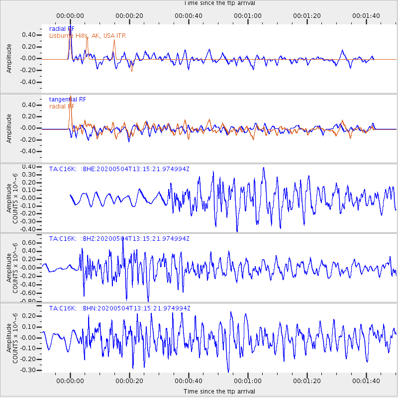
C16K Lisburne Hills, AK, USA - Earthquake Result Viewer
*The percent match for this event was below the threshold and hence no stack was calculated.
| Earthquake location: |
Near East Coast Of Honshu, Japan |
| Earthquake latitude/longitude: |
35.7/140.9 |
| Earthquake time(UTC): |
2020/05/04 (125) 13:07:48 GMT |
| Earthquake Depth: |
41 km |
| Earthquake Magnitude: |
5.6 Mww |
| Earthquake Catalog/Contributor: |
NEIC PDE/us |
|
| Network: |
TA USArray Transportable Network (new EarthScope stations) |
| Station: |
C16K Lisburne Hills, AK, USA |
| Lat/Lon: |
68.27 N/165.34 W |
| Elevation: |
102 m |
|
| Distance: |
44.1 deg |
| Az: |
25.561 deg |
| Baz: |
250.658 deg |
| Ray Param: |
$rayparam |
*The percent match for this event was below the threshold and hence was not used in the summary stack. |
|
| Radial Match: |
68.09959 % |
| Radial Bump: |
400 |
| Transverse Match: |
68.72071 % |
| Transverse Bump: |
400 |
| SOD ConfigId: |
21166931 |
| Insert Time: |
2020-05-18 13:23:22.321 +0000 |
| GWidth: |
2.5 |
| Max Bumps: |
400 |
| Tol: |
0.001 |
|
Signal To Noise
| Channel | StoN | STA | LTA |
| TA:C16K: :BHZ:20200504T13:15:21.974994Z | 3.1283565 | 1.9995548E-7 | 6.3917106E-8 |
| TA:C16K: :BHN:20200504T13:15:21.974994Z | 1.4771886 | 7.1482866E-8 | 4.8391158E-8 |
| TA:C16K: :BHE:20200504T13:15:21.974994Z | 1.4878311 | 8.2789406E-8 | 5.5644357E-8 |
| Arrivals |
| Ps | |
| PpPs | |
| PsPs/PpSs | |


