You are here: Home > Network List > US - United States National Seismic Network Stations List
> Station MNTX Cornudas Mountains, Texas, USA > Earthquake Result Viewer
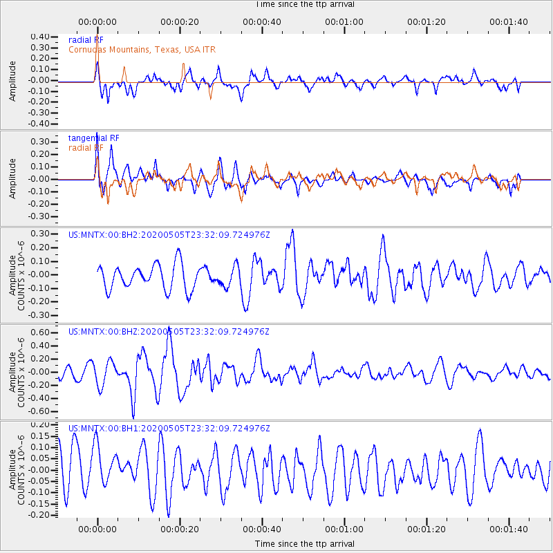
MNTX Cornudas Mountains, Texas, USA - Earthquake Result Viewer
*The percent match for this event was below the threshold and hence no stack was calculated.
| Earthquake location: |
Samoa Islands |
| Earthquake latitude/longitude: |
-14.7/-172.4 |
| Earthquake time(UTC): |
2020/05/05 (126) 23:20:40 GMT |
| Earthquake Depth: |
33 km |
| Earthquake Magnitude: |
5.6 Mi |
| Earthquake Catalog/Contributor: |
NEIC PDE/pt |
|
| Network: |
US United States National Seismic Network |
| Station: |
MNTX Cornudas Mountains, Texas, USA |
| Lat/Lon: |
31.70 N/105.38 W |
| Elevation: |
404 m |
|
| Distance: |
79.0 deg |
| Az: |
53.071 deg |
| Baz: |
245.164 deg |
| Ray Param: |
$rayparam |
*The percent match for this event was below the threshold and hence was not used in the summary stack. |
|
| Radial Match: |
43.789177 % |
| Radial Bump: |
400 |
| Transverse Match: |
45.096684 % |
| Transverse Bump: |
400 |
| SOD ConfigId: |
21166931 |
| Insert Time: |
2020-05-19 23:35:29.741 +0000 |
| GWidth: |
2.5 |
| Max Bumps: |
400 |
| Tol: |
0.001 |
|
Signal To Noise
| Channel | StoN | STA | LTA |
| US:MNTX:00:BHZ:20200505T23:32:09.724976Z | 2.909218 | 1.8339361E-7 | 6.30388E-8 |
| US:MNTX:00:BH1:20200505T23:32:09.724976Z | 0.9756682 | 1.0961812E-7 | 1.1235185E-7 |
| US:MNTX:00:BH2:20200505T23:32:09.724976Z | 0.7999859 | 7.251126E-8 | 9.0640675E-8 |
| Arrivals |
| Ps | |
| PpPs | |
| PsPs/PpSs | |


