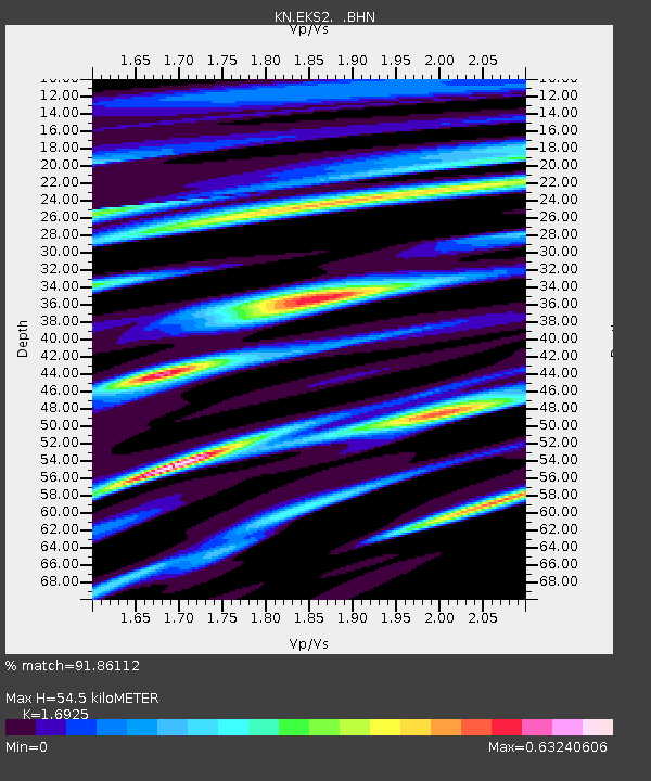
EKS2 KN.EKS2 - Earthquake Result Viewer

Earthquake location: Southwest Of Sumatra, Indonesia
Earthquake latitude/longitude: -0.2/97.7
Earthquake time(UTC): 2005/04/08 (098) 05:48:37 GMT
Earthquake Depth: 21 km
Earthquake Magnitude: 5.7 MB, 6.3 MS, 6.1 MW, 6.1 MW
Earthquake Catalog/Contributor: WHDF/NEIC
Network: KN Kyrgyz Seismic Telemetry Network
Station: EKS2 KN.EKS2
Lat/Lon: 42.66 N/73.78 E
Elevation: 1360 m
Distance: 47.8 deg
Az: 336.159 deg
Baz: 146.773 deg
Ray Param: 0.06972643
Estimated Moho Depth: 54.5 km
Estimated Crust Vp/Vs: 1.69
Assumed Crust Vp: 6.316 km/s
Estimated Crust Vs: 3.731 km/s
Estimated Crust Poisson's Ratio: 0.23
Radial Match: 91.86112 %
Radial Bump: 400
Transverse Match: 61.9839 %
Transverse Bump: 400
SOD ConfigId: 2459
Insert Time: 2010-03-08 19:51:45.617 +0000
GWidth: 2.5
Max Bumps: 400
Tol: 0.001

Signal To Noise

ChannelStoNSTALTA
KN:EKS2: :BHN:20050408T05:56:42.950007Z1.69750451.4953719E-78.8092364E-8
KN:EKS2: :BHE:20050408T05:56:42.950007Z2.33350042.846202E-71.2197135E-7
KN:EKS2: :BHZ:20050408T05:56:42.950007Z3.41074323.872817E-71.1354759E-7
Arrivals
Ps6.4 SECOND
PpPs22 SECOND
PsPs/PpSs28 SECOND