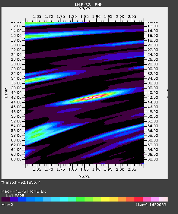
EKS2 KN.EKS2 - Earthquake Result Viewer
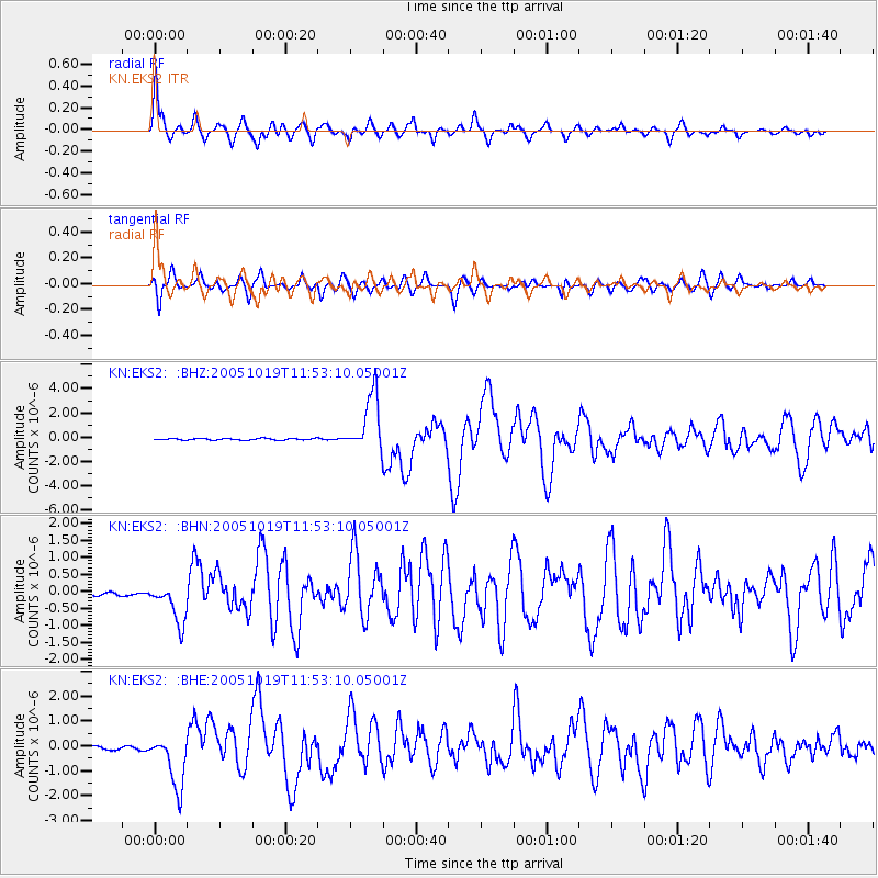
Earthquake location: Near East Coast Of Honshu, Japan
Earthquake latitude/longitude: 36.4/140.8
Earthquake time(UTC): 2005/10/19 (292) 11:44:42 GMT
Earthquake Depth: 32 km
Earthquake Magnitude: 6.2 MB, 6.5 MS, 6.4 MW, 6.3 MW
Earthquake Catalog/Contributor: WHDF/NEIC
Network: KN Kyrgyz Seismic Telemetry Network
Station: EKS2 KN.EKS2
Lat/Lon: 42.66 N/73.78 E
Elevation: 1360 m
Distance: 50.9 deg
Az: 298.89 deg
Baz: 73.252 deg
Ray Param: 0.06770334
Estimated Moho Depth: 41.75 km
Estimated Crust Vp/Vs: 1.88
Assumed Crust Vp: 6.316 km/s
Estimated Crust Vs: 3.355 km/s
Estimated Crust Poisson's Ratio: 0.30
Radial Match: 92.185074 %
Radial Bump: 400
Transverse Match: 87.06705 %
Transverse Bump: 400
SOD ConfigId: 2475
Insert Time: 2010-03-08 19:52:00.017 +0000
GWidth: 2.5
Max Bumps: 400
Tol: 0.001

Signal To Noise

ChannelStoNSTALTA
KN:EKS2: :BHN:20051019T11:53:10.05001Z8.8891516.13659E-76.9034606E-8
KN:EKS2: :BHE:20051019T11:53:10.05001Z13.6468481.0901495E-67.9882874E-8
KN:EKS2: :BHZ:20051019T11:53:10.05001Z36.623952.3733307E-66.480269E-8
Arrivals
Ps6.1 SECOND
PpPs18 SECOND
PsPs/PpSs24 SECOND