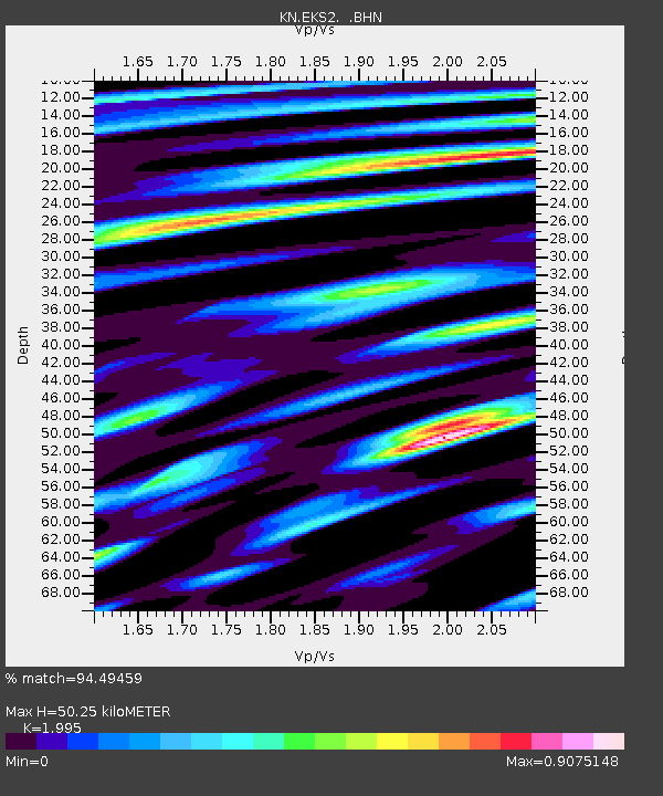
EKS2 KN.EKS2 - Earthquake Result Viewer
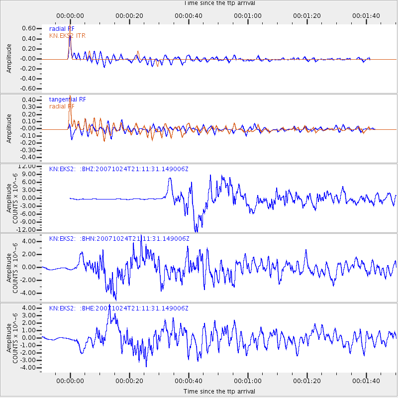
Earthquake location: Southern Sumatra, Indonesia
Earthquake latitude/longitude: -3.9/101.0
Earthquake time(UTC): 2007/10/24 (297) 21:02:50 GMT
Earthquake Depth: 20 km
Earthquake Magnitude: 6.1 MB, 6.9 MS, 6.8 MW, 6.3 ME
Earthquake Catalog/Contributor: WHDF/NEIC
Network: KN Kyrgyz Seismic Telemetry Network
Station: EKS2 KN.EKS2
Lat/Lon: 42.66 N/73.78 E
Elevation: 1360 m
Distance: 52.5 deg
Az: 334.813 deg
Baz: 144.857 deg
Ray Param: 0.066695586
Estimated Moho Depth: 50.25 km
Estimated Crust Vp/Vs: 2.00
Assumed Crust Vp: 6.316 km/s
Estimated Crust Vs: 3.166 km/s
Estimated Crust Poisson's Ratio: 0.33
Radial Match: 94.49459 %
Radial Bump: 400
Transverse Match: 82.44015 %
Transverse Bump: 400
SOD ConfigId: 2564
Insert Time: 2010-03-08 19:52:23.506 +0000
GWidth: 2.5
Max Bumps: 400
Tol: 0.001

Signal To Noise

ChannelStoNSTALTA
KN:EKS2: :BHN:20071024T21:11:31.149006Z6.24780651.0785158E-61.726231E-7
KN:EKS2: :BHE:20071024T21:11:31.149006Z6.6867039.4108736E-71.4074011E-7
KN:EKS2: :BHZ:20071024T21:11:31.149006Z37.1583943.4967552E-69.410404E-8
Arrivals
Ps8.3 SECOND
PpPs23 SECOND
PsPs/PpSs31 SECOND