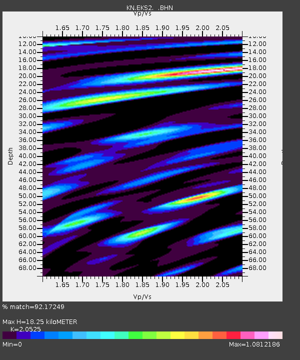
EKS2 KN.EKS2 - Earthquake Result Viewer

Earthquake location: Southern Sumatra, Indonesia
Earthquake latitude/longitude: -2.0/100.1
Earthquake time(UTC): 2007/09/20 (263) 08:31:14 GMT
Earthquake Depth: 30 km
Earthquake Magnitude: 6.3 MB, 6.8 MS, 6.7 MW, 6.3 ME
Earthquake Catalog/Contributor: WHDF/NEIC
Network: KN Kyrgyz Seismic Telemetry Network
Station: EKS2 KN.EKS2
Lat/Lon: 42.66 N/73.78 E
Elevation: 1360 m
Distance: 50.4 deg
Az: 334.85 deg
Baz: 144.845 deg
Ray Param: 0.06801181
Estimated Moho Depth: 18.25 km
Estimated Crust Vp/Vs: 2.05
Assumed Crust Vp: 6.316 km/s
Estimated Crust Vs: 3.077 km/s
Estimated Crust Poisson's Ratio: 0.34
Radial Match: 92.17249 %
Radial Bump: 400
Transverse Match: 82.54062 %
Transverse Bump: 400
SOD ConfigId: 2564
Insert Time: 2010-03-08 19:52:35.006 +0000
GWidth: 2.5
Max Bumps: 400
Tol: 0.001

Signal To Noise

ChannelStoNSTALTA
KN:EKS2: :BHN:20070920T08:39:38.474009Z6.4552765.2731264E-78.1687084E-8
KN:EKS2: :BHE:20070920T08:39:38.474009Z7.38715653.4444E-74.6626873E-8
KN:EKS2: :BHZ:20070920T08:39:38.474009Z25.0690611.209678E-64.825382E-8
Arrivals
Ps3.2 SECOND
PpPs8.4 SECOND
PsPs/PpSs12 SECOND