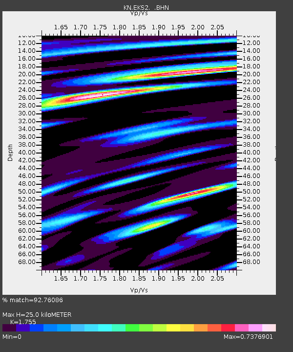
EKS2 KN.EKS2 - Earthquake Result Viewer
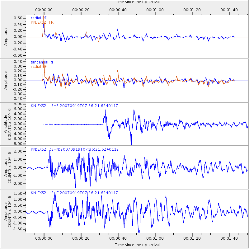
Earthquake location: Southern Sumatra, Indonesia
Earthquake latitude/longitude: -2.7/100.9
Earthquake time(UTC): 2007/09/19 (262) 07:27:50 GMT
Earthquake Depth: 35 km
Earthquake Magnitude: 5.7 MB, 5.8 MS, 6.0 MW, 5.9 MW
Earthquake Catalog/Contributor: WHDF/NEIC
Network: KN Kyrgyz Seismic Telemetry Network
Station: EKS2 KN.EKS2
Lat/Lon: 42.66 N/73.78 E
Elevation: 1360 m
Distance: 51.4 deg
Az: 334.526 deg
Baz: 144.379 deg
Ray Param: 0.06736293
Estimated Moho Depth: 25.0 km
Estimated Crust Vp/Vs: 1.75
Assumed Crust Vp: 6.316 km/s
Estimated Crust Vs: 3.599 km/s
Estimated Crust Poisson's Ratio: 0.26
Radial Match: 92.76086 %
Radial Bump: 400
Transverse Match: 88.41986 %
Transverse Bump: 400
SOD ConfigId: 2564
Insert Time: 2010-03-08 19:52:36.761 +0000
GWidth: 2.5
Max Bumps: 400
Tol: 0.001

Signal To Noise

ChannelStoNSTALTA
KN:EKS2: :BHN:20070919T07:36:21.624011Z4.73339946.8067436E-71.4380244E-7
KN:EKS2: :BHE:20070919T07:36:21.624011Z6.15912445.42733E-78.811853E-8
KN:EKS2: :BHZ:20070919T07:36:21.624011Z27.8473952.0465422E-67.3491336E-8
Arrivals
Ps3.2 SECOND
PpPs10 SECOND
PsPs/PpSs13 SECOND