You are here: Home > Network List > TA - USArray Transportable Network (new EarthScope stations) Stations List
> Station D25K Kavik River, AK, USA > Earthquake Result Viewer
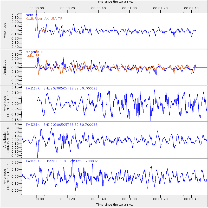
D25K Kavik River, AK, USA - Earthquake Result Viewer
*The percent match for this event was below the threshold and hence no stack was calculated.
| Earthquake location: |
Samoa Islands Region |
| Earthquake latitude/longitude: |
-15.2/-172.9 |
| Earthquake time(UTC): |
2020/05/05 (126) 23:20:40 GMT |
| Earthquake Depth: |
10 km |
| Earthquake Magnitude: |
5.5 mb |
| Earthquake Catalog/Contributor: |
NEIC PDE/us |
|
| Network: |
TA USArray Transportable Network (new EarthScope stations) |
| Station: |
D25K Kavik River, AK, USA |
| Lat/Lon: |
69.32 N/146.38 W |
| Elevation: |
770 m |
|
| Distance: |
86.3 deg |
| Az: |
9.157 deg |
| Baz: |
205.634 deg |
| Ray Param: |
$rayparam |
*The percent match for this event was below the threshold and hence was not used in the summary stack. |
|
| Radial Match: |
62.472897 % |
| Radial Bump: |
400 |
| Transverse Match: |
73.710526 % |
| Transverse Bump: |
400 |
| SOD ConfigId: |
21166931 |
| Insert Time: |
2020-05-19 23:49:45.641 +0000 |
| GWidth: |
2.5 |
| Max Bumps: |
400 |
| Tol: |
0.001 |
|
Signal To Noise
| Channel | StoN | STA | LTA |
| TA:D25K: :BHZ:20200505T23:32:50.70003Z | 3.236865 | 1.8818034E-7 | 5.81366E-8 |
| TA:D25K: :BHN:20200505T23:32:50.70003Z | 2.5330532 | 8.1825945E-8 | 3.230329E-8 |
| TA:D25K: :BHE:20200505T23:32:50.70003Z | 1.232319 | 5.5873187E-8 | 4.533987E-8 |
| Arrivals |
| Ps | |
| PpPs | |
| PsPs/PpSs | |


