You are here: Home > Network List > TA - USArray Transportable Network (new EarthScope stations) Stations List
> Station F20K Avaraart Lake, AK, USA > Earthquake Result Viewer
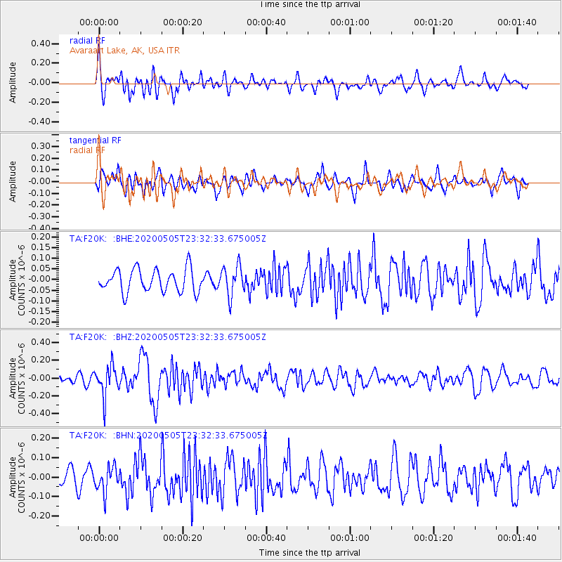
F20K Avaraart Lake, AK, USA - Earthquake Result Viewer
*The percent match for this event was below the threshold and hence no stack was calculated.
| Earthquake location: |
Samoa Islands Region |
| Earthquake latitude/longitude: |
-15.2/-172.9 |
| Earthquake time(UTC): |
2020/05/05 (126) 23:20:40 GMT |
| Earthquake Depth: |
10 km |
| Earthquake Magnitude: |
5.5 mb |
| Earthquake Catalog/Contributor: |
NEIC PDE/us |
|
| Network: |
TA USArray Transportable Network (new EarthScope stations) |
| Station: |
F20K Avaraart Lake, AK, USA |
| Lat/Lon: |
67.05 N/155.73 W |
| Elevation: |
136 m |
|
| Distance: |
83.0 deg |
| Az: |
6.714 deg |
| Baz: |
196.729 deg |
| Ray Param: |
$rayparam |
*The percent match for this event was below the threshold and hence was not used in the summary stack. |
|
| Radial Match: |
66.57931 % |
| Radial Bump: |
400 |
| Transverse Match: |
62.136475 % |
| Transverse Bump: |
400 |
| SOD ConfigId: |
21166931 |
| Insert Time: |
2020-05-19 23:50:11.278 +0000 |
| GWidth: |
2.5 |
| Max Bumps: |
400 |
| Tol: |
0.001 |
|
Signal To Noise
| Channel | StoN | STA | LTA |
| TA:F20K: :BHZ:20200505T23:32:33.675005Z | 2.8509288 | 1.7490888E-7 | 6.135154E-8 |
| TA:F20K: :BHN:20200505T23:32:33.675005Z | 1.2264811 | 6.6444656E-8 | 5.4175036E-8 |
| TA:F20K: :BHE:20200505T23:32:33.675005Z | 1.3284032 | 7.076088E-8 | 5.3267627E-8 |
| Arrivals |
| Ps | |
| PpPs | |
| PsPs/PpSs | |


