You are here: Home > Network List > TA - USArray Transportable Network (new EarthScope stations) Stations List
> Station L15K Ungalak Mountain, AK, USA > Earthquake Result Viewer
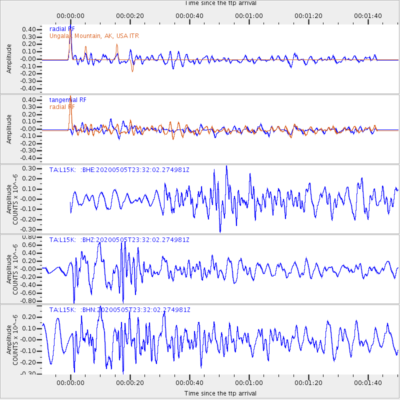
L15K Ungalak Mountain, AK, USA - Earthquake Result Viewer
*The percent match for this event was below the threshold and hence no stack was calculated.
| Earthquake location: |
Samoa Islands Region |
| Earthquake latitude/longitude: |
-15.2/-172.9 |
| Earthquake time(UTC): |
2020/05/05 (126) 23:20:40 GMT |
| Earthquake Depth: |
10 km |
| Earthquake Magnitude: |
5.5 mb |
| Earthquake Catalog/Contributor: |
NEIC PDE/us |
|
| Network: |
TA USArray Transportable Network (new EarthScope stations) |
| Station: |
L15K Ungalak Mountain, AK, USA |
| Lat/Lon: |
61.68 N/161.49 W |
| Elevation: |
219 m |
|
| Distance: |
77.1 deg |
| Az: |
5.572 deg |
| Baz: |
191.337 deg |
| Ray Param: |
$rayparam |
*The percent match for this event was below the threshold and hence was not used in the summary stack. |
|
| Radial Match: |
69.78335 % |
| Radial Bump: |
400 |
| Transverse Match: |
53.232475 % |
| Transverse Bump: |
400 |
| SOD ConfigId: |
21166931 |
| Insert Time: |
2020-05-19 23:50:59.553 +0000 |
| GWidth: |
2.5 |
| Max Bumps: |
400 |
| Tol: |
0.001 |
|
Signal To Noise
| Channel | StoN | STA | LTA |
| TA:L15K: :BHZ:20200505T23:32:02.274981Z | 4.5633087 | 3.1210809E-7 | 6.839513E-8 |
| TA:L15K: :BHN:20200505T23:32:02.274981Z | 1.3061415 | 9.5613714E-8 | 7.320318E-8 |
| TA:L15K: :BHE:20200505T23:32:02.274981Z | 1.6872087 | 8.5742116E-8 | 5.081892E-8 |
| Arrivals |
| Ps | |
| PpPs | |
| PsPs/PpSs | |


