You are here: Home > Network List > TA - USArray Transportable Network (new EarthScope stations) Stations List
> Station M31M Drury Creek, Yukon, CA > Earthquake Result Viewer
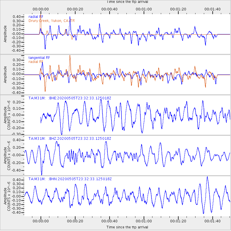
M31M Drury Creek, Yukon, CA - Earthquake Result Viewer
*The percent match for this event was below the threshold and hence no stack was calculated.
| Earthquake location: |
Samoa Islands Region |
| Earthquake latitude/longitude: |
-15.2/-172.9 |
| Earthquake time(UTC): |
2020/05/05 (126) 23:20:40 GMT |
| Earthquake Depth: |
10 km |
| Earthquake Magnitude: |
5.5 mb |
| Earthquake Catalog/Contributor: |
NEIC PDE/us |
|
| Network: |
TA USArray Transportable Network (new EarthScope stations) |
| Station: |
M31M Drury Creek, Yukon, CA |
| Lat/Lon: |
62.20 N/134.39 W |
| Elevation: |
639 m |
|
| Distance: |
82.9 deg |
| Az: |
17.122 deg |
| Baz: |
217.328 deg |
| Ray Param: |
$rayparam |
*The percent match for this event was below the threshold and hence was not used in the summary stack. |
|
| Radial Match: |
72.22257 % |
| Radial Bump: |
400 |
| Transverse Match: |
42.723278 % |
| Transverse Bump: |
400 |
| SOD ConfigId: |
21166931 |
| Insert Time: |
2020-05-19 23:51:14.920 +0000 |
| GWidth: |
2.5 |
| Max Bumps: |
400 |
| Tol: |
0.001 |
|
Signal To Noise
| Channel | StoN | STA | LTA |
| TA:M31M: :BHZ:20200505T23:32:33.125018Z | 2.63479 | 2.3397186E-7 | 8.880095E-8 |
| TA:M31M: :BHN:20200505T23:32:33.125018Z | 1.2344465 | 1.083842E-7 | 8.779984E-8 |
| TA:M31M: :BHE:20200505T23:32:33.125018Z | 0.80151105 | 9.059474E-8 | 1.13029934E-7 |
| Arrivals |
| Ps | |
| PpPs | |
| PsPs/PpSs | |


