You are here: Home > Network List > TX - Texas Seismological Network Stations List
> Station WTFS Witchita Falls > Earthquake Result Viewer
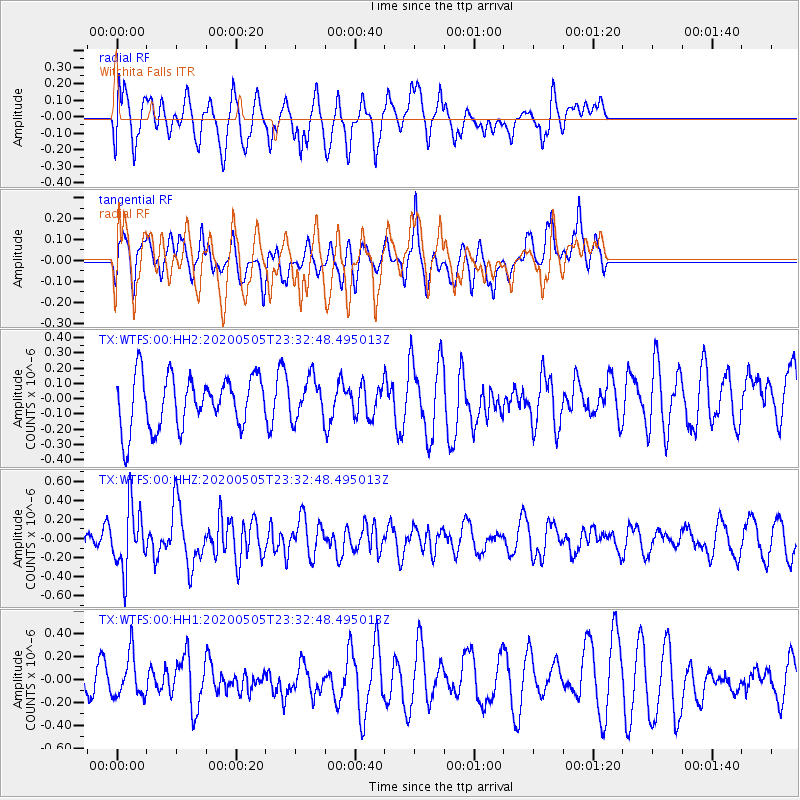
WTFS Witchita Falls - Earthquake Result Viewer
*The percent match for this event was below the threshold and hence no stack was calculated.
| Earthquake location: |
Samoa Islands Region |
| Earthquake latitude/longitude: |
-15.2/-172.9 |
| Earthquake time(UTC): |
2020/05/05 (126) 23:20:40 GMT |
| Earthquake Depth: |
10 km |
| Earthquake Magnitude: |
5.5 mb |
| Earthquake Catalog/Contributor: |
NEIC PDE/us |
|
| Network: |
TX Texas Seismological Network |
| Station: |
WTFS Witchita Falls |
| Lat/Lon: |
33.77 N/98.46 W |
| Elevation: |
277 m |
|
| Distance: |
85.9 deg |
| Az: |
53.579 deg |
| Baz: |
248.864 deg |
| Ray Param: |
$rayparam |
*The percent match for this event was below the threshold and hence was not used in the summary stack. |
|
| Radial Match: |
66.38998 % |
| Radial Bump: |
400 |
| Transverse Match: |
49.549515 % |
| Transverse Bump: |
387 |
| SOD ConfigId: |
21166931 |
| Insert Time: |
2020-05-19 23:52:31.752 +0000 |
| GWidth: |
2.5 |
| Max Bumps: |
400 |
| Tol: |
0.001 |
|
Signal To Noise
| Channel | StoN | STA | LTA |
| TX:WTFS:00:HHZ:20200505T23:32:48.495013Z | 4.066775 | 3.249262E-7 | 7.989776E-8 |
| TX:WTFS:00:HH1:20200505T23:32:48.495013Z | 1.2505833 | 1.8352492E-7 | 1.4675146E-7 |
| TX:WTFS:00:HH2:20200505T23:32:48.495013Z | 0.77570856 | 1.3201627E-7 | 1.7018797E-7 |
| Arrivals |
| Ps | |
| PpPs | |
| PsPs/PpSs | |


