You are here: Home > Network List > UU - University of Utah Regional Network Stations List
> Station HMU Henry Mountain, UT, USA > Earthquake Result Viewer
HMU Henry Mountain, UT, USA - Earthquake Result Viewer
| Earthquake location: |
South Of Alaska |
| Earthquake latitude/longitude: |
53.8/-161.0 |
| Earthquake time(UTC): |
2017/05/28 (148) 07:37:08 GMT |
| Earthquake Depth: |
10 km |
| Earthquake Magnitude: |
5.0 mb |
| Earthquake Catalog/Contributor: |
NEIC PDE/us |
|
| Network: |
UU University of Utah Regional Network |
| Station: |
HMU Henry Mountain, UT, USA |
| Lat/Lon: |
37.94 N/110.74 W |
| Elevation: |
2430 m |
|
| Distance: |
37.5 deg |
| Az: |
94.086 deg |
| Baz: |
311.499 deg |
| Ray Param: |
0.076077424 |
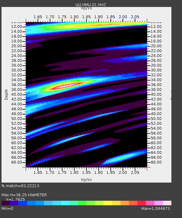
| Estimated Moho Depth: |
36.25 km |
| Estimated Crust Vp/Vs: |
1.76 |
| Assumed Crust Vp: |
6.247 km/s |
| Estimated Crust Vs: |
3.544 km/s |
| Estimated Crust Poisson's Ratio: |
0.26 |
|
| Radial Match: |
83.22213 % |
| Radial Bump: |
400 |
| Transverse Match: |
37.128536 % |
| Transverse Bump: |
400 |
| SOD ConfigId: |
2028011 |
| Insert Time: |
2017-06-11 07:47:14.017 +0000 |
| GWidth: |
2.5 |
| Max Bumps: |
400 |
| Tol: |
0.001 |
|

Signal To Noise
| Channel | StoN | STA | LTA |
| UU:HMU:01:HHZ:20170528T07:43:51.44801Z | 1.2537581 | 3.277393E-9 | 2.6140554E-9 |
| UU:HMU:01:HHN:20170528T07:43:51.44801Z | 0.97176063 | 4.08608E-9 | 4.2048214E-9 |
| UU:HMU:01:HHE:20170528T07:43:51.44801Z | 0.86782455 | 3.7152386E-9 | 4.281094E-9 |
| Arrivals |
| Ps | 4.7 SECOND |
| PpPs | 15 SECOND |
| PsPs/PpSs | 20 SECOND |


