You are here: Home > Network List > GO - National Seismic Network of Georgia Stations List
> Station ONI Oni > Earthquake Result Viewer
ONI Oni - Earthquake Result Viewer
| Earthquake location: |
Sulawesi, Indonesia |
| Earthquake latitude/longitude: |
-1.3/120.5 |
| Earthquake time(UTC): |
2017/05/29 (149) 14:35:20 GMT |
| Earthquake Depth: |
9.4 km |
| Earthquake Magnitude: |
6.6 Mww |
| Earthquake Catalog/Contributor: |
NEIC PDE/us |
|
| Network: |
GO National Seismic Network of Georgia |
| Station: |
ONI Oni |
| Lat/Lon: |
42.59 N/43.45 E |
| Elevation: |
810 m |
|
| Distance: |
81.3 deg |
| Az: |
313.284 deg |
| Baz: |
99.758 deg |
| Ray Param: |
0.04767318 |
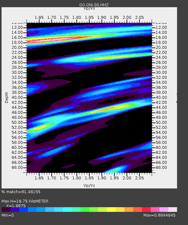
| Estimated Moho Depth: |
16.75 km |
| Estimated Crust Vp/Vs: |
1.70 |
| Assumed Crust Vp: |
6.247 km/s |
| Estimated Crust Vs: |
3.68 km/s |
| Estimated Crust Poisson's Ratio: |
0.23 |
|
| Radial Match: |
91.46155 % |
| Radial Bump: |
391 |
| Transverse Match: |
84.08539 % |
| Transverse Bump: |
400 |
| SOD ConfigId: |
2028011 |
| Insert Time: |
2017-06-12 14:36:17.965 +0000 |
| GWidth: |
2.5 |
| Max Bumps: |
400 |
| Tol: |
0.001 |
|
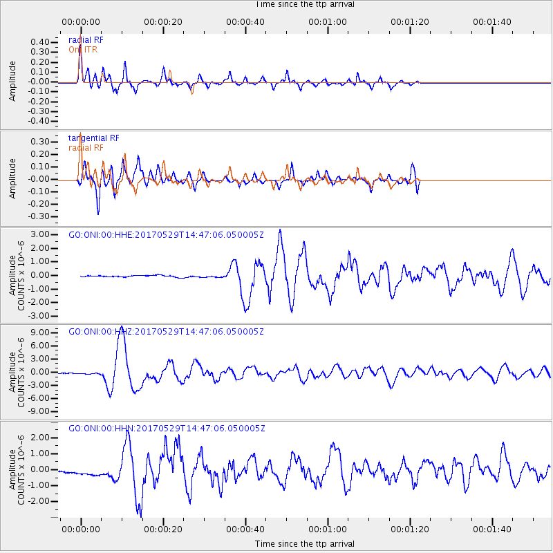
Signal To Noise
| Channel | StoN | STA | LTA |
| GO:ONI:00:HHZ:20170529T14:47:06.050005Z | 2.916351 | 1.330293E-7 | 4.5614982E-8 |
| GO:ONI:00:HHN:20170529T14:47:06.050005Z | 4.3250303 | 3.1958857E-7 | 7.389279E-8 |
| GO:ONI:00:HHE:20170529T14:47:06.050005Z | 1.2622031 | 7.455343E-8 | 5.9066107E-8 |
| Arrivals |
| Ps | 1.9 SECOND |
| PpPs | 7.0 SECOND |
| PsPs/PpSs | 9.0 SECOND |


