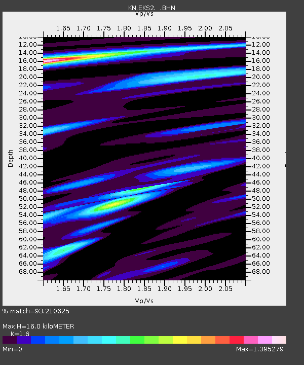
EKS2 KN.EKS2 - Earthquake Result Viewer
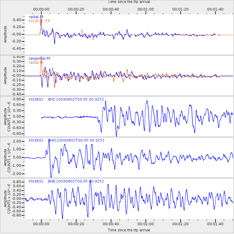
Earthquake location: Irian Jaya Region, Indonesia
Earthquake latitude/longitude: -0.5/132.9
Earthquake time(UTC): 2009/08/02 (214) 08:54:35 GMT
Earthquake Depth: 35 km
Earthquake Magnitude: 5.8 MB, 5.8 MS, 6.1 MW, 6.0 MW
Earthquake Catalog/Contributor: WHDF/NEIC
Network: KN Kyrgyz Seismic Telemetry Network
Station: EKS2 KN.EKS2
Lat/Lon: 42.66 N/73.78 E
Elevation: 1360 m
Distance: 68.1 deg
Az: 316.973 deg
Baz: 112.33 deg
Ray Param: 0.056474157
Estimated Moho Depth: 16.0 km
Estimated Crust Vp/Vs: 1.60
Assumed Crust Vp: 6.316 km/s
Estimated Crust Vs: 3.947 km/s
Estimated Crust Poisson's Ratio: 0.18
Radial Match: 93.210625 %
Radial Bump: 400
Transverse Match: 93.57939 %
Transverse Bump: 400
SOD ConfigId: 2622
Insert Time: 2010-03-08 19:54:11.138 +0000
GWidth: 2.5
Max Bumps: 400
Tol: 0.001

Signal To Noise

ChannelStoNSTALTA
KN:EKS2: :BHN:20090802T09:05:00.925Z18.2786988.4437335E-74.6194394E-8
KN:EKS2: :BHE:20090802T09:05:00.925Z1.72010926.645264E-83.8632802E-8
KN:EKS2: :BHZ:20090802T09:05:00.925Z13.1541312.8332403E-72.1538787E-8
Arrivals
Ps1.6 SECOND
PpPs6.3 SECOND
PsPs/PpSs7.9 SECOND