You are here: Home > Network List > AV - Alaska Volcano Observatory Stations List
> Station AUSS Augustine Summit Station, Augustine Volcano, Alaska > Earthquake Result Viewer
AUSS Augustine Summit Station, Augustine Volcano, Alaska - Earthquake Result Viewer
| Earthquake location: |
Banda Sea |
| Earthquake latitude/longitude: |
-6.8/129.9 |
| Earthquake time(UTC): |
2020/05/06 (127) 13:53:56 GMT |
| Earthquake Depth: |
107 km |
| Earthquake Magnitude: |
6.8 Mww |
| Earthquake Catalog/Contributor: |
NEIC PDE/us |
|
| Network: |
AV Alaska Volcano Observatory |
| Station: |
AUSS Augustine Summit Station, Augustine Volcano, Alaska |
| Lat/Lon: |
59.36 N/153.43 W |
| Elevation: |
1235 m |
|
| Distance: |
89.1 deg |
| Az: |
29.903 deg |
| Baz: |
255.147 deg |
| Ray Param: |
0.0418949 |
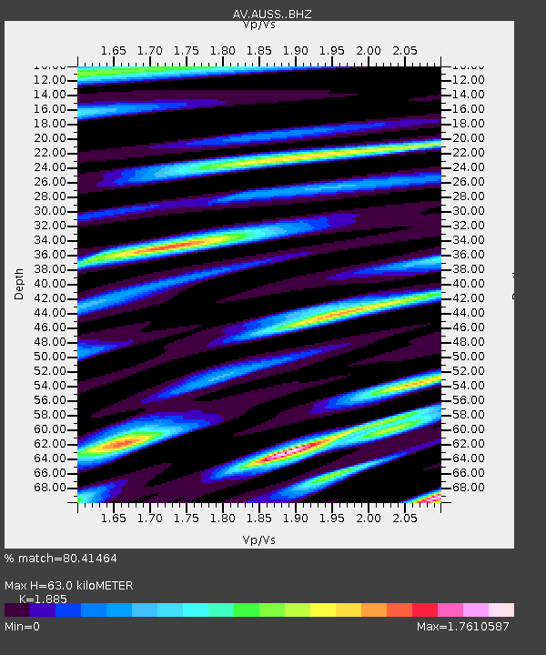
| Estimated Moho Depth: |
63.0 km |
| Estimated Crust Vp/Vs: |
1.88 |
| Assumed Crust Vp: |
5.989 km/s |
| Estimated Crust Vs: |
3.177 km/s |
| Estimated Crust Poisson's Ratio: |
0.30 |
|
| Radial Match: |
80.41464 % |
| Radial Bump: |
302 |
| Transverse Match: |
84.532196 % |
| Transverse Bump: |
304 |
| SOD ConfigId: |
21166931 |
| Insert Time: |
2020-05-20 13:57:48.325 +0000 |
| GWidth: |
2.5 |
| Max Bumps: |
400 |
| Tol: |
0.001 |
|
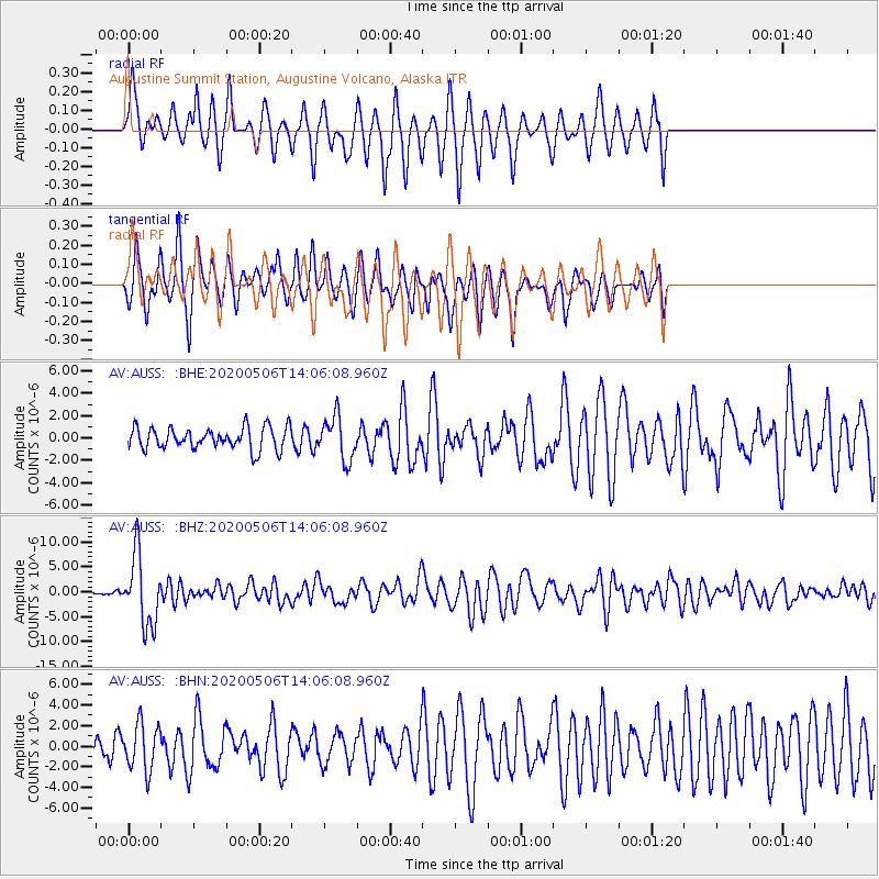
Signal To Noise
| Channel | StoN | STA | LTA |
| AV:AUSS: :BHZ:20200506T14:06:08.960Z | 19.014368 | 7.0413653E-6 | 3.7031813E-7 |
| AV:AUSS: :BHN:20200506T14:06:08.960Z | 3.360742 | 2.2523054E-6 | 6.7018095E-7 |
| AV:AUSS: :BHE:20200506T14:06:08.960Z | 1.9662993 | 1.9216975E-6 | 9.77317E-7 |
| Arrivals |
| Ps | 9.5 SECOND |
| PpPs | 30 SECOND |
| PsPs/PpSs | 39 SECOND |


