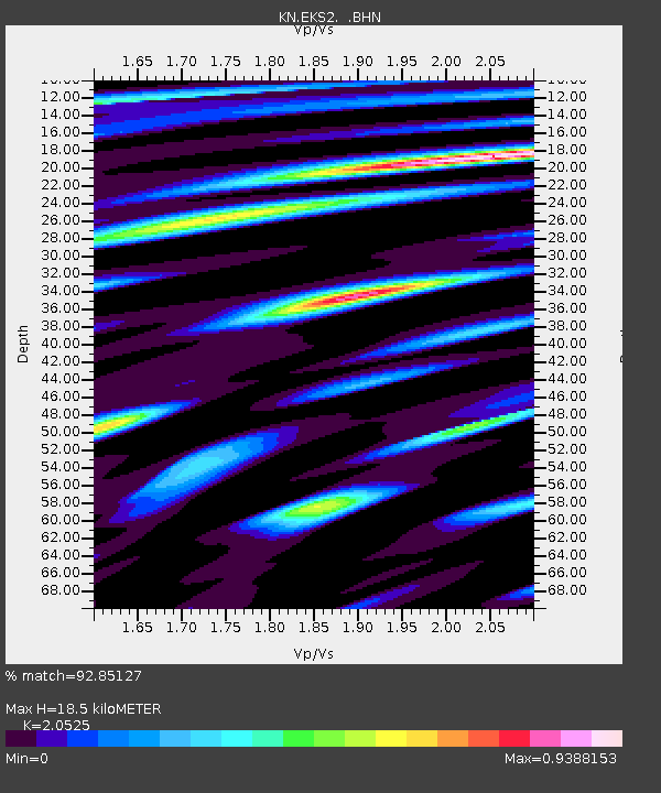
EKS2 KN.EKS2 - Earthquake Result Viewer

Earthquake location: Southern Sumatra, Indonesia
Earthquake latitude/longitude: -1.5/99.5
Earthquake time(UTC): 2009/08/16 (228) 07:38:21 GMT
Earthquake Depth: 20 km
Earthquake Magnitude: 6.5 MB, 6.7 MS, 6.7 MW, 6.5 MW
Earthquake Catalog/Contributor: WHDF/NEIC
Network: KN Kyrgyz Seismic Telemetry Network
Station: EKS2 KN.EKS2
Lat/Lon: 42.66 N/73.78 E
Elevation: 1360 m
Distance: 49.7 deg
Az: 335.181 deg
Baz: 145.329 deg
Ray Param: 0.06852204
Estimated Moho Depth: 18.5 km
Estimated Crust Vp/Vs: 2.05
Assumed Crust Vp: 6.316 km/s
Estimated Crust Vs: 3.077 km/s
Estimated Crust Poisson's Ratio: 0.34
Radial Match: 92.85127 %
Radial Bump: 400
Transverse Match: 90.134285 %
Transverse Bump: 400
SOD ConfigId: 2622
Insert Time: 2010-03-08 19:54:22.137 +0000
GWidth: 2.5
Max Bumps: 400
Tol: 0.001

Signal To Noise

ChannelStoNSTALTA
KN:EKS2: :BHN:20090816T07:46:41.200Z18.382471.4990626E-68.154849E-8
KN:EKS2: :BHE:20090816T07:46:41.200Z5.7068124.497544E-77.8810096E-8
KN:EKS2: :BHZ:20090816T07:46:41.200Z6.53237963.7621834E-75.759285E-8
Arrivals
Ps3.2 SECOND
PpPs8.5 SECOND
PsPs/PpSs12 SECOND