You are here: Home > Network List > AV - Alaska Volcano Observatory Stations List
> Station KAWH Katmai, Alaska > Earthquake Result Viewer
KAWH Katmai, Alaska - Earthquake Result Viewer
| Earthquake location: |
Banda Sea |
| Earthquake latitude/longitude: |
-6.8/129.9 |
| Earthquake time(UTC): |
2020/05/06 (127) 13:53:56 GMT |
| Earthquake Depth: |
107 km |
| Earthquake Magnitude: |
6.8 Mww |
| Earthquake Catalog/Contributor: |
NEIC PDE/us |
|
| Network: |
AV Alaska Volcano Observatory |
| Station: |
KAWH Katmai, Alaska |
| Lat/Lon: |
58.38 N/154.80 W |
| Elevation: |
777 m |
|
| Distance: |
88.1 deg |
| Az: |
30.658 deg |
| Baz: |
253.995 deg |
| Ray Param: |
0.04258582 |
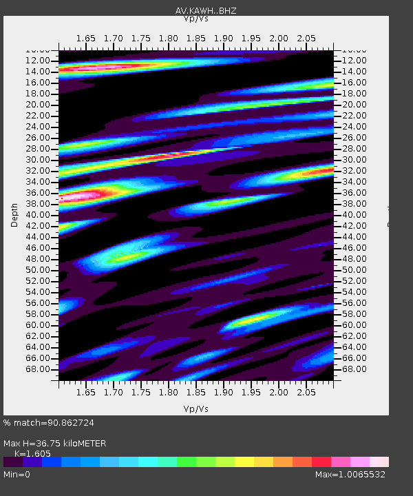
| Estimated Moho Depth: |
36.75 km |
| Estimated Crust Vp/Vs: |
1.61 |
| Assumed Crust Vp: |
6.438 km/s |
| Estimated Crust Vs: |
4.011 km/s |
| Estimated Crust Poisson's Ratio: |
0.18 |
|
| Radial Match: |
90.862724 % |
| Radial Bump: |
400 |
| Transverse Match: |
86.70667 % |
| Transverse Bump: |
400 |
| SOD ConfigId: |
21166931 |
| Insert Time: |
2020-05-20 13:58:27.788 +0000 |
| GWidth: |
2.5 |
| Max Bumps: |
400 |
| Tol: |
0.001 |
|

Signal To Noise
| Channel | StoN | STA | LTA |
| AV:KAWH: :BHZ:20200506T14:06:04.519998Z | 22.808113 | 3.0824933E-6 | 1.3514898E-7 |
| AV:KAWH: :BHN:20200506T14:06:04.519998Z | 5.529128 | 5.4067715E-7 | 9.778706E-8 |
| AV:KAWH: :BHE:20200506T14:06:04.519998Z | 14.238063 | 1.5110221E-6 | 1.0612555E-7 |
| Arrivals |
| Ps | 3.5 SECOND |
| PpPs | 15 SECOND |
| PsPs/PpSs | 18 SECOND |


