You are here: Home > Network List > G - GEOSCOPE Stations List
> Station ATD Arta Cave - Arta, Republic of Djibouti > Earthquake Result Viewer
ATD Arta Cave - Arta, Republic of Djibouti - Earthquake Result Viewer
| Earthquake location: |
Banda Sea |
| Earthquake latitude/longitude: |
-6.8/129.9 |
| Earthquake time(UTC): |
2020/05/06 (127) 13:53:56 GMT |
| Earthquake Depth: |
107 km |
| Earthquake Magnitude: |
6.8 Mww |
| Earthquake Catalog/Contributor: |
NEIC PDE/us |
|
| Network: |
G GEOSCOPE |
| Station: |
ATD Arta Cave - Arta, Republic of Djibouti |
| Lat/Lon: |
11.53 N/42.85 E |
| Elevation: |
610 m |
|
| Distance: |
88.4 deg |
| Az: |
281.73 deg |
| Baz: |
97.21 deg |
| Ray Param: |
0.042365514 |
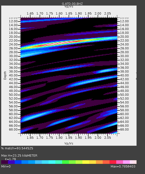
| Estimated Moho Depth: |
23.25 km |
| Estimated Crust Vp/Vs: |
1.79 |
| Assumed Crust Vp: |
6.375 km/s |
| Estimated Crust Vs: |
3.561 km/s |
| Estimated Crust Poisson's Ratio: |
0.27 |
|
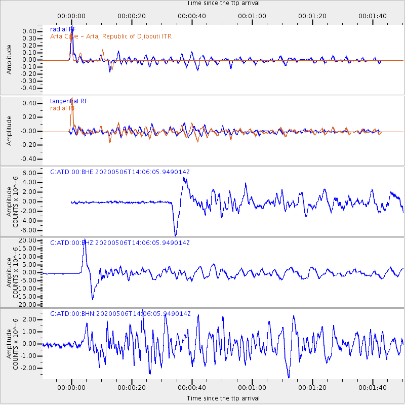
| Radial Match: |
93.544525 % |
| Radial Bump: |
400 |
| Transverse Match: |
84.27284 % |
| Transverse Bump: |
400 |
| SOD ConfigId: |
21166931 |
| Insert Time: |
2020-05-20 14:00:08.195 +0000 |
| GWidth: |
2.5 |
| Max Bumps: |
400 |
| Tol: |
0.001 |
|
Signal To Noise
| Channel | StoN | STA | LTA |
| G:ATD:00:BHZ:20200506T14:06:05.949014Z | 70.88112 | 7.904681E-6 | 1.1152027E-7 |
| G:ATD:00:BHN:20200506T14:06:05.949014Z | 5.706654 | 4.1374258E-7 | 7.2501784E-8 |
| G:ATD:00:BHE:20200506T14:06:05.949014Z | 25.231642 | 2.5982838E-6 | 1.02977204E-7 |
| Arrivals |
| Ps | 2.9 SECOND |
| PpPs | 10.0 SECOND |
| PsPs/PpSs | 13 SECOND |


