You are here: Home > Network List > IU - Global Seismograph Network (GSN - IRIS/USGS) Stations List
> Station MA2 Magadan, Russia > Earthquake Result Viewer
MA2 Magadan, Russia - Earthquake Result Viewer

| Earthquake location: |
Sulawesi, Indonesia |
| Earthquake latitude/longitude: |
-1.3/120.5 |
| Earthquake time(UTC): |
2017/05/29 (149) 14:35:20 GMT |
| Earthquake Depth: |
9.4 km |
| Earthquake Magnitude: |
6.6 Mww |
| Earthquake Catalog/Contributor: |
NEIC PDE/us |
|
| Network: |
IU Global Seismograph Network (GSN - IRIS/USGS) |
| Station: |
MA2 Magadan, Russia |
| Lat/Lon: |
59.58 N/150.77 E |
| Elevation: |
339 m |
|
| Distance: |
65.1 deg |
| Az: |
16.436 deg |
| Baz: |
213.766 deg |
| Ray Param: |
0.058471587 |
| Estimated Moho Depth: |
58.25 km |
| Estimated Crust Vp/Vs: |
2.10 |
| Assumed Crust Vp: |
6.134 km/s |
| Estimated Crust Vs: |
2.924 km/s |
| Estimated Crust Poisson's Ratio: |
0.35 |
|
| Radial Match: |
96.79196 % |
| Radial Bump: |
382 |
| Transverse Match: |
90.59873 % |
| Transverse Bump: |
400 |
| SOD ConfigId: |
2028011 |
| Insert Time: |
2017-06-12 14:37:11.222 +0000 |
| GWidth: |
2.5 |
| Max Bumps: |
400 |
| Tol: |
0.001 |
|
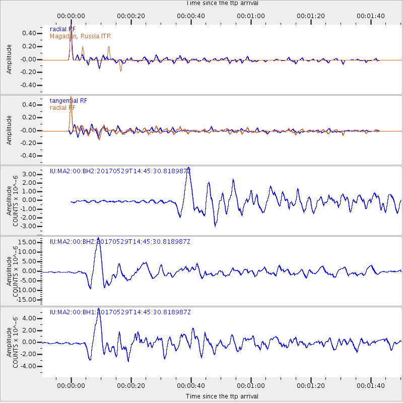
Signal To Noise
| Channel | StoN | STA | LTA |
| IU:MA2:00:BHZ:20170529T14:45:30.818987Z | 2.6383474 | 3.5359386E-7 | 1.3402096E-7 |
| IU:MA2:00:BH1:20170529T14:45:30.818987Z | 1.2540426 | 1.10891754E-7 | 8.842742E-8 |
| IU:MA2:00:BH2:20170529T14:45:30.818987Z | 1.4459839 | 1.0287987E-7 | 7.11487E-8 |
| Arrivals |
| Ps | 11 SECOND |
| PpPs | 28 SECOND |
| PsPs/PpSs | 39 SECOND |


