You are here: Home > Network List > GO - National Seismic Network of Georgia Stations List
> Station TBLG Delisi, Georgia > Earthquake Result Viewer
TBLG Delisi, Georgia - Earthquake Result Viewer
| Earthquake location: |
Banda Sea |
| Earthquake latitude/longitude: |
-6.8/129.9 |
| Earthquake time(UTC): |
2020/05/06 (127) 13:53:56 GMT |
| Earthquake Depth: |
107 km |
| Earthquake Magnitude: |
6.8 Mww |
| Earthquake Catalog/Contributor: |
NEIC PDE/us |
|
| Network: |
GO National Seismic Network of Georgia |
| Station: |
TBLG Delisi, Georgia |
| Lat/Lon: |
41.73 N/44.74 E |
| Elevation: |
510 m |
|
| Distance: |
90.8 deg |
| Az: |
311.766 deg |
| Baz: |
98.278 deg |
| Ray Param: |
0.04164192 |
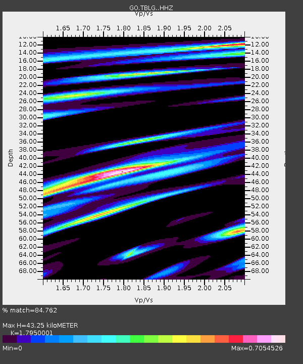
| Estimated Moho Depth: |
43.25 km |
| Estimated Crust Vp/Vs: |
1.80 |
| Assumed Crust Vp: |
6.291 km/s |
| Estimated Crust Vs: |
3.505 km/s |
| Estimated Crust Poisson's Ratio: |
0.27 |
|
| Radial Match: |
84.762 % |
| Radial Bump: |
400 |
| Transverse Match: |
82.99825 % |
| Transverse Bump: |
400 |
| SOD ConfigId: |
21166931 |
| Insert Time: |
2020-05-20 14:00:33.329 +0000 |
| GWidth: |
2.5 |
| Max Bumps: |
400 |
| Tol: |
0.001 |
|
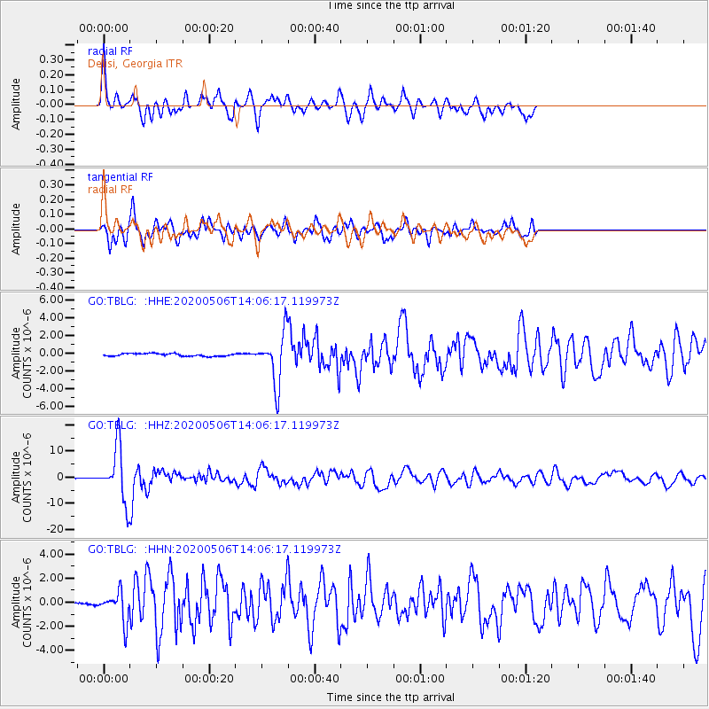
Signal To Noise
| Channel | StoN | STA | LTA |
| GO:TBLG: :HHZ:20200506T14:06:17.119973Z | 140.66498 | 1.030984E-5 | 7.3293585E-8 |
| GO:TBLG: :HHN:20200506T14:06:17.119973Z | 11.567185 | 1.2562522E-6 | 1.0860483E-7 |
| GO:TBLG: :HHE:20200506T14:06:17.119973Z | 19.644197 | 2.8904178E-6 | 1.4713851E-7 |
| Arrivals |
| Ps | 5.6 SECOND |
| PpPs | 19 SECOND |
| PsPs/PpSs | 24 SECOND |


