You are here: Home > Network List > IU - Global Seismograph Network (GSN - IRIS/USGS) Stations List
> Station QSPA South Pole Remote Earth Science Observatory (Quiet Zone) > Earthquake Result Viewer
QSPA South Pole Remote Earth Science Observatory (Quiet Zone) - Earthquake Result Viewer

| Earthquake location: |
Sulawesi, Indonesia |
| Earthquake latitude/longitude: |
-1.3/120.5 |
| Earthquake time(UTC): |
2017/05/29 (149) 14:35:20 GMT |
| Earthquake Depth: |
9.4 km |
| Earthquake Magnitude: |
6.6 Mww |
| Earthquake Catalog/Contributor: |
NEIC PDE/us |
|
| Network: |
IU Global Seismograph Network (GSN - IRIS/USGS) |
| Station: |
QSPA South Pole Remote Earth Science Observatory (Quiet Zone) |
| Lat/Lon: |
89.93 S/144.44 E |
| Elevation: |
2850 m |
|
| Distance: |
88.7 deg |
| Az: |
179.971 deg |
| Baz: |
336.039 deg |
| Ray Param: |
0.042408373 |
| Estimated Moho Depth: |
33.0 km |
| Estimated Crust Vp/Vs: |
1.88 |
| Assumed Crust Vp: |
6.193 km/s |
| Estimated Crust Vs: |
3.285 km/s |
| Estimated Crust Poisson's Ratio: |
0.30 |
|
| Radial Match: |
92.13296 % |
| Radial Bump: |
400 |
| Transverse Match: |
85.04154 % |
| Transverse Bump: |
400 |
| SOD ConfigId: |
2028011 |
| Insert Time: |
2017-06-12 14:37:21.556 +0000 |
| GWidth: |
2.5 |
| Max Bumps: |
400 |
| Tol: |
0.001 |
|
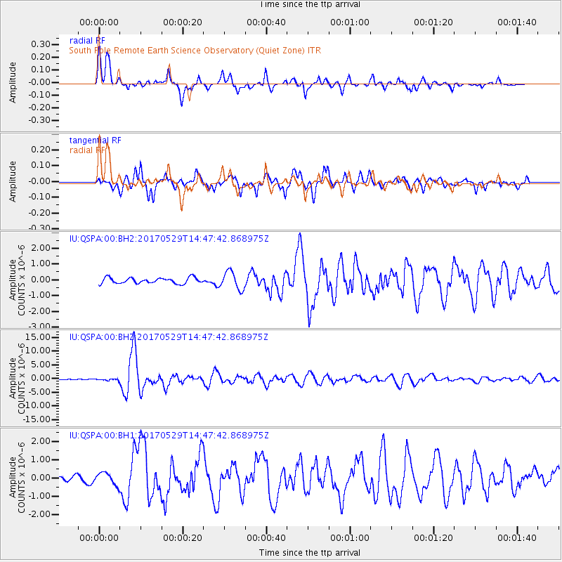
Signal To Noise
| Channel | StoN | STA | LTA |
| IU:QSPA:00:BHZ:20170529T14:47:42.868975Z | 1.3644214 | 3.4462778E-7 | 2.5258163E-7 |
| IU:QSPA:00:BH1:20170529T14:47:42.868975Z | 2.1646216 | 3.379154E-7 | 1.561083E-7 |
| IU:QSPA:00:BH2:20170529T14:47:42.868975Z | 3.1505487 | 5.692456E-7 | 1.8068144E-7 |
| Arrivals |
| Ps | 4.8 SECOND |
| PpPs | 15 SECOND |
| PsPs/PpSs | 20 SECOND |


