You are here: Home > Network List > PS - Pacific21 Stations List
> Station PATS 6onpei, Micronesia > Earthquake Result Viewer
PATS 6onpei, Micronesia - Earthquake Result Viewer

| Earthquake location: |
Banda Sea |
| Earthquake latitude/longitude: |
-6.8/129.9 |
| Earthquake time(UTC): |
2020/05/06 (127) 13:53:56 GMT |
| Earthquake Depth: |
107 km |
| Earthquake Magnitude: |
6.8 Mww |
| Earthquake Catalog/Contributor: |
NEIC PDE/us |
|
| Network: |
PS Pacific21 |
| Station: |
PATS 6onpei, Micronesia |
| Lat/Lon: |
6.84 N/158.32 E |
| Elevation: |
10 m |
|
| Distance: |
31.5 deg |
| Az: |
65.057 deg |
| Baz: |
245.067 deg |
| Ray Param: |
0.078800805 |
| Estimated Moho Depth: |
14.75 km |
| Estimated Crust Vp/Vs: |
1.82 |
| Assumed Crust Vp: |
4.24 km/s |
| Estimated Crust Vs: |
2.326 km/s |
| Estimated Crust Poisson's Ratio: |
0.28 |
|
| Radial Match: |
85.09328 % |
| Radial Bump: |
400 |
| Transverse Match: |
70.28575 % |
| Transverse Bump: |
400 |
| SOD ConfigId: |
21166931 |
| Insert Time: |
2020-05-20 14:03:30.896 +0000 |
| GWidth: |
2.5 |
| Max Bumps: |
400 |
| Tol: |
0.001 |
|
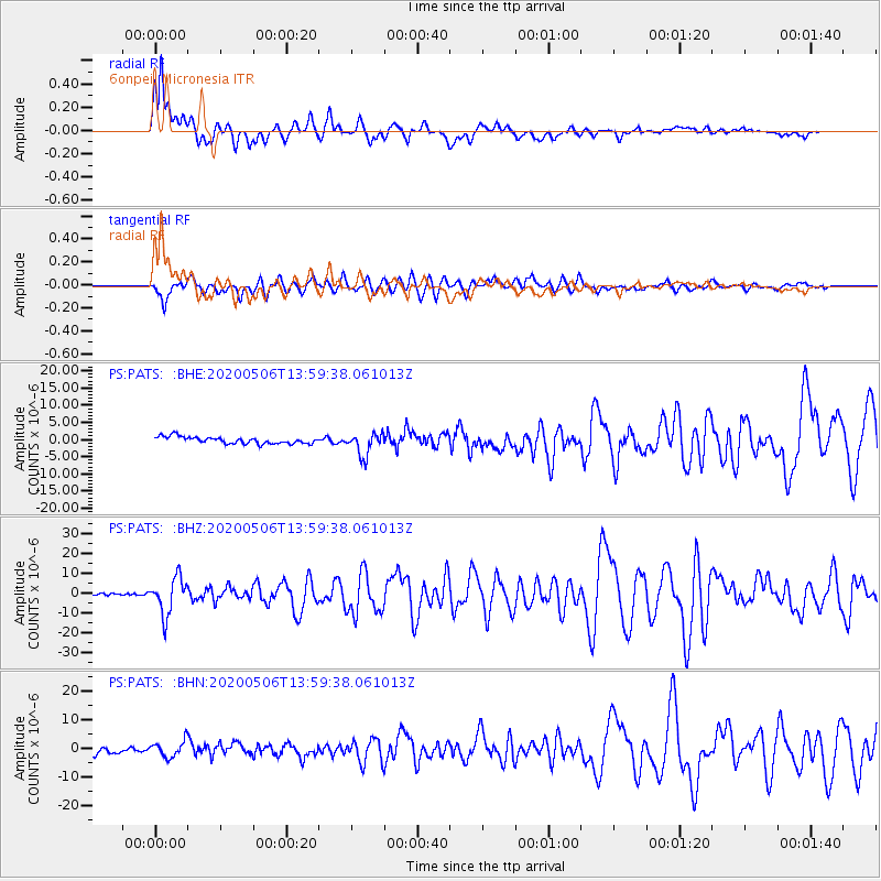
Signal To Noise
| Channel | StoN | STA | LTA |
| PS:PATS: :BHZ:20200506T13:59:38.061013Z | 8.583337 | 9.185092E-6 | 1.0701073E-6 |
| PS:PATS: :BHN:20200506T13:59:38.061013Z | 1.4213196 | 2.8881107E-6 | 2.0319926E-6 |
| PS:PATS: :BHE:20200506T13:59:38.061013Z | 3.2781937 | 3.2818548E-6 | 1.0011169E-6 |
| Arrivals |
| Ps | 3.0 SECOND |
| PpPs | 9.5 SECOND |
| PsPs/PpSs | 12 SECOND |


