You are here: Home > Network List > TA - USArray Transportable Network (new EarthScope stations) Stations List
> Station F20K Avaraart Lake, AK, USA > Earthquake Result Viewer
F20K Avaraart Lake, AK, USA - Earthquake Result Viewer
| Earthquake location: |
Banda Sea |
| Earthquake latitude/longitude: |
-6.8/129.9 |
| Earthquake time(UTC): |
2020/05/06 (127) 13:53:56 GMT |
| Earthquake Depth: |
107 km |
| Earthquake Magnitude: |
6.8 Mww |
| Earthquake Catalog/Contributor: |
NEIC PDE/us |
|
| Network: |
TA USArray Transportable Network (new EarthScope stations) |
| Station: |
F20K Avaraart Lake, AK, USA |
| Lat/Lon: |
67.05 N/155.73 W |
| Elevation: |
136 m |
|
| Distance: |
90.2 deg |
| Az: |
22.195 deg |
| Baz: |
253.049 deg |
| Ray Param: |
0.041699916 |
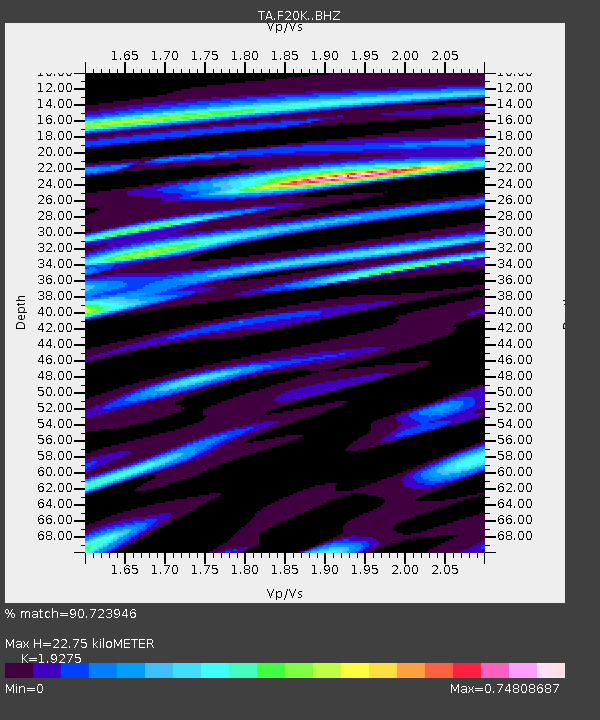
| Estimated Moho Depth: |
22.75 km |
| Estimated Crust Vp/Vs: |
1.93 |
| Assumed Crust Vp: |
6.522 km/s |
| Estimated Crust Vs: |
3.383 km/s |
| Estimated Crust Poisson's Ratio: |
0.32 |
|
| Radial Match: |
90.723946 % |
| Radial Bump: |
400 |
| Transverse Match: |
73.27631 % |
| Transverse Bump: |
400 |
| SOD ConfigId: |
21166931 |
| Insert Time: |
2020-05-20 14:04:59.590 +0000 |
| GWidth: |
2.5 |
| Max Bumps: |
400 |
| Tol: |
0.001 |
|
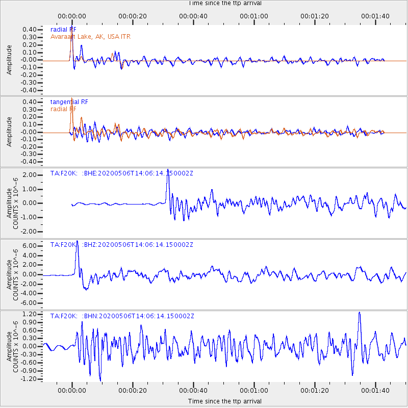
Signal To Noise
| Channel | StoN | STA | LTA |
| TA:F20K: :BHZ:20200506T14:06:14.150002Z | 55.348957 | 2.91622E-6 | 5.2687895E-8 |
| TA:F20K: :BHN:20200506T14:06:14.150002Z | 5.8076544 | 3.885573E-7 | 6.690434E-8 |
| TA:F20K: :BHE:20200506T14:06:14.150002Z | 21.5617 | 9.181468E-7 | 4.2582297E-8 |
| Arrivals |
| Ps | 3.3 SECOND |
| PpPs | 10 SECOND |
| PsPs/PpSs | 13 SECOND |


