You are here: Home > Network List > TA - USArray Transportable Network (new EarthScope stations) Stations List
> Station J14K Nanvaranak Lake, AK, USA > Earthquake Result Viewer
J14K Nanvaranak Lake, AK, USA - Earthquake Result Viewer
| Earthquake location: |
Banda Sea |
| Earthquake latitude/longitude: |
-6.8/129.9 |
| Earthquake time(UTC): |
2020/05/06 (127) 13:53:56 GMT |
| Earthquake Depth: |
107 km |
| Earthquake Magnitude: |
6.8 Mww |
| Earthquake Catalog/Contributor: |
NEIC PDE/us |
|
| Network: |
TA USArray Transportable Network (new EarthScope stations) |
| Station: |
J14K Nanvaranak Lake, AK, USA |
| Lat/Lon: |
62.75 N/163.55 W |
| Elevation: |
25 m |
|
| Distance: |
85.6 deg |
| Az: |
25.067 deg |
| Baz: |
246.068 deg |
| Ray Param: |
0.04444916 |
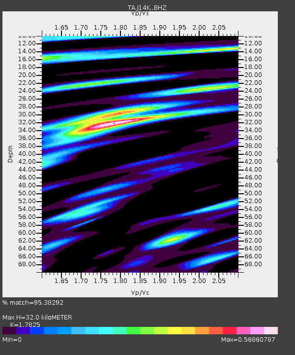
| Estimated Moho Depth: |
32.0 km |
| Estimated Crust Vp/Vs: |
1.78 |
| Assumed Crust Vp: |
6.155 km/s |
| Estimated Crust Vs: |
3.453 km/s |
| Estimated Crust Poisson's Ratio: |
0.27 |
|
| Radial Match: |
95.38292 % |
| Radial Bump: |
389 |
| Transverse Match: |
87.092705 % |
| Transverse Bump: |
400 |
| SOD ConfigId: |
21166931 |
| Insert Time: |
2020-05-20 14:05:44.717 +0000 |
| GWidth: |
2.5 |
| Max Bumps: |
400 |
| Tol: |
0.001 |
|

Signal To Noise
| Channel | StoN | STA | LTA |
| TA:J14K: :BHZ:20200506T14:05:52.100015Z | 118.98022 | 8.713653E-6 | 7.323615E-8 |
| TA:J14K: :BHN:20200506T14:05:52.100015Z | 17.897709 | 1.2529993E-6 | 7.0008916E-8 |
| TA:J14K: :BHE:20200506T14:05:52.100015Z | 46.95472 | 2.9538946E-6 | 6.2909436E-8 |
| Arrivals |
| Ps | 4.2 SECOND |
| PpPs | 14 SECOND |
| PsPs/PpSs | 18 SECOND |


