You are here: Home > Network List > TA - USArray Transportable Network (new EarthScope stations) Stations List
> Station N17K Nushagak Hills, AK, USA > Earthquake Result Viewer
N17K Nushagak Hills, AK, USA - Earthquake Result Viewer
| Earthquake location: |
Banda Sea |
| Earthquake latitude/longitude: |
-6.8/129.9 |
| Earthquake time(UTC): |
2020/05/06 (127) 13:53:56 GMT |
| Earthquake Depth: |
107 km |
| Earthquake Magnitude: |
6.8 Mww |
| Earthquake Catalog/Contributor: |
NEIC PDE/us |
|
| Network: |
TA USArray Transportable Network (new EarthScope stations) |
| Station: |
N17K Nushagak Hills, AK, USA |
| Lat/Lon: |
60.53 N/157.19 W |
| Elevation: |
350 m |
|
| Distance: |
87.6 deg |
| Az: |
28.243 deg |
| Baz: |
251.854 deg |
| Ray Param: |
0.042981323 |
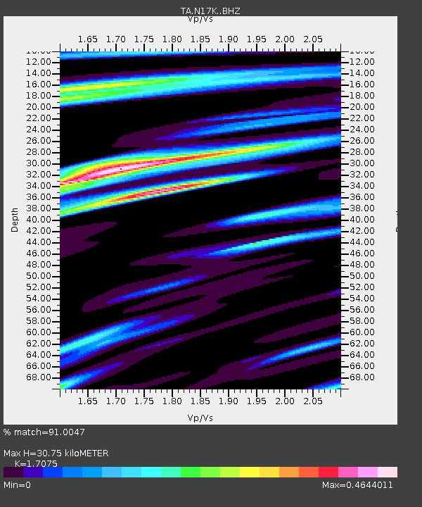
| Estimated Moho Depth: |
30.75 km |
| Estimated Crust Vp/Vs: |
1.71 |
| Assumed Crust Vp: |
6.155 km/s |
| Estimated Crust Vs: |
3.605 km/s |
| Estimated Crust Poisson's Ratio: |
0.24 |
|
| Radial Match: |
91.0047 % |
| Radial Bump: |
395 |
| Transverse Match: |
80.605316 % |
| Transverse Bump: |
400 |
| SOD ConfigId: |
21166931 |
| Insert Time: |
2020-05-20 14:06:23.705 +0000 |
| GWidth: |
2.5 |
| Max Bumps: |
400 |
| Tol: |
0.001 |
|

Signal To Noise
| Channel | StoN | STA | LTA |
| TA:N17K: :BHZ:20200506T14:06:01.999978Z | 25.216963 | 5.304632E-6 | 2.1035967E-7 |
| TA:N17K: :BHN:20200506T14:06:01.999978Z | 5.372202 | 5.304474E-7 | 9.873929E-8 |
| TA:N17K: :BHE:20200506T14:06:01.999978Z | 11.836462 | 1.6044438E-6 | 1.3555096E-7 |
| Arrivals |
| Ps | 3.6 SECOND |
| PpPs | 13 SECOND |
| PsPs/PpSs | 17 SECOND |


