You are here: Home > Network List > TA - USArray Transportable Network (new EarthScope stations) Stations List
> Station O15K Ungalikthiuk River, AK, USA > Earthquake Result Viewer
O15K Ungalikthiuk River, AK, USA - Earthquake Result Viewer
| Earthquake location: |
Banda Sea |
| Earthquake latitude/longitude: |
-6.8/129.9 |
| Earthquake time(UTC): |
2020/05/06 (127) 13:53:56 GMT |
| Earthquake Depth: |
107 km |
| Earthquake Magnitude: |
6.8 Mww |
| Earthquake Catalog/Contributor: |
NEIC PDE/us |
|
| Network: |
TA USArray Transportable Network (new EarthScope stations) |
| Station: |
O15K Ungalikthiuk River, AK, USA |
| Lat/Lon: |
59.18 N/159.82 W |
| Elevation: |
306 m |
|
| Distance: |
85.9 deg |
| Az: |
29.083 deg |
| Baz: |
249.624 deg |
| Ray Param: |
0.044213485 |
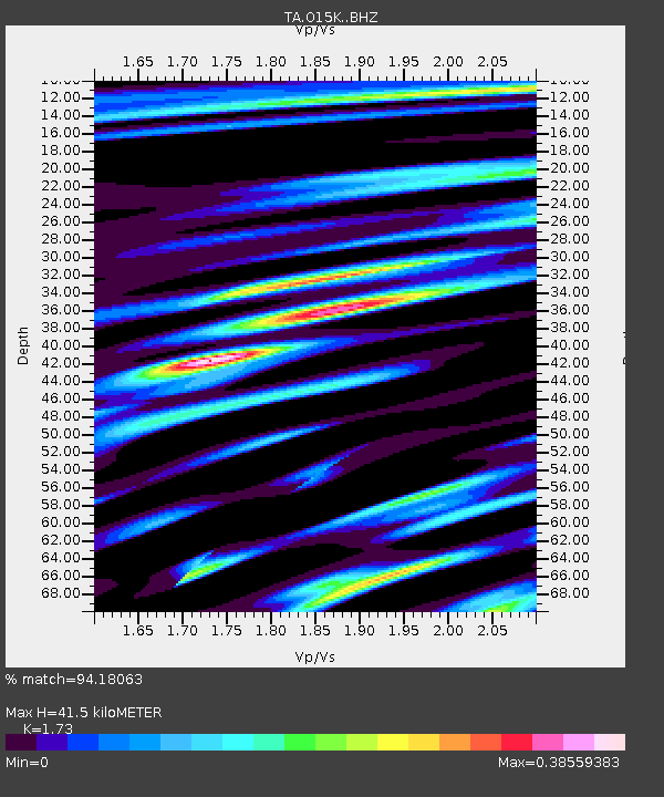
| Estimated Moho Depth: |
41.5 km |
| Estimated Crust Vp/Vs: |
1.73 |
| Assumed Crust Vp: |
6.24 km/s |
| Estimated Crust Vs: |
3.607 km/s |
| Estimated Crust Poisson's Ratio: |
0.25 |
|
| Radial Match: |
94.18063 % |
| Radial Bump: |
400 |
| Transverse Match: |
77.29034 % |
| Transverse Bump: |
400 |
| SOD ConfigId: |
21166931 |
| Insert Time: |
2020-05-20 14:06:29.466 +0000 |
| GWidth: |
2.5 |
| Max Bumps: |
400 |
| Tol: |
0.001 |
|

Signal To Noise
| Channel | StoN | STA | LTA |
| TA:O15K: :BHZ:20200506T14:05:53.749978Z | 55.950397 | 6.201357E-6 | 1.10836694E-7 |
| TA:O15K: :BHN:20200506T14:05:53.749978Z | 10.421157 | 8.093441E-7 | 7.766356E-8 |
| TA:O15K: :BHE:20200506T14:05:53.749978Z | 16.173418 | 1.8872884E-6 | 1.16690764E-7 |
| Arrivals |
| Ps | 5.0 SECOND |
| PpPs | 18 SECOND |
| PsPs/PpSs | 23 SECOND |


