You are here: Home > Network List > TA - USArray Transportable Network (new EarthScope stations) Stations List
> Station R31K City Hall, Gustavus, AK, USA > Earthquake Result Viewer
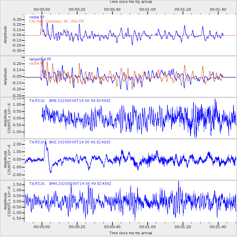
R31K City Hall, Gustavus, AK, USA - Earthquake Result Viewer
*The percent match for this event was below the threshold and hence no stack was calculated.
| Earthquake location: |
Banda Sea |
| Earthquake latitude/longitude: |
-6.8/129.9 |
| Earthquake time(UTC): |
2020/05/06 (127) 13:53:56 GMT |
| Earthquake Depth: |
107 km |
| Earthquake Magnitude: |
6.8 Mww |
| Earthquake Catalog/Contributor: |
NEIC PDE/us |
|
| Network: |
TA USArray Transportable Network (new EarthScope stations) |
| Station: |
R31K City Hall, Gustavus, AK, USA |
| Lat/Lon: |
58.41 N/135.74 W |
| Elevation: |
15 m |
|
| Distance: |
98.0 deg |
| Az: |
32.006 deg |
| Baz: |
270.168 deg |
| Ray Param: |
$rayparam |
*The percent match for this event was below the threshold and hence was not used in the summary stack. |
|
| Radial Match: |
57.48625 % |
| Radial Bump: |
400 |
| Transverse Match: |
55.04282 % |
| Transverse Bump: |
400 |
| SOD ConfigId: |
21166931 |
| Insert Time: |
2020-05-20 14:06:40.935 +0000 |
| GWidth: |
2.5 |
| Max Bumps: |
400 |
| Tol: |
0.001 |
|
Signal To Noise
| Channel | StoN | STA | LTA |
| TA:R31K: :BHZ:20200506T14:06:49.82499Z | 4.837632 | 1.1819321E-6 | 2.4432038E-7 |
| TA:R31K: :BHN:20200506T14:06:49.82499Z | 0.9039314 | 3.4768348E-7 | 3.8463483E-7 |
| TA:R31K: :BHE:20200506T14:06:49.82499Z | 1.261532 | 4.1608146E-7 | 3.2982237E-7 |
| Arrivals |
| Ps | |
| PpPs | |
| PsPs/PpSs | |


