You are here: Home > Network List > GS - US Geological Survey Networks Stations List
> Station DEC06 Boomer > Earthquake Result Viewer
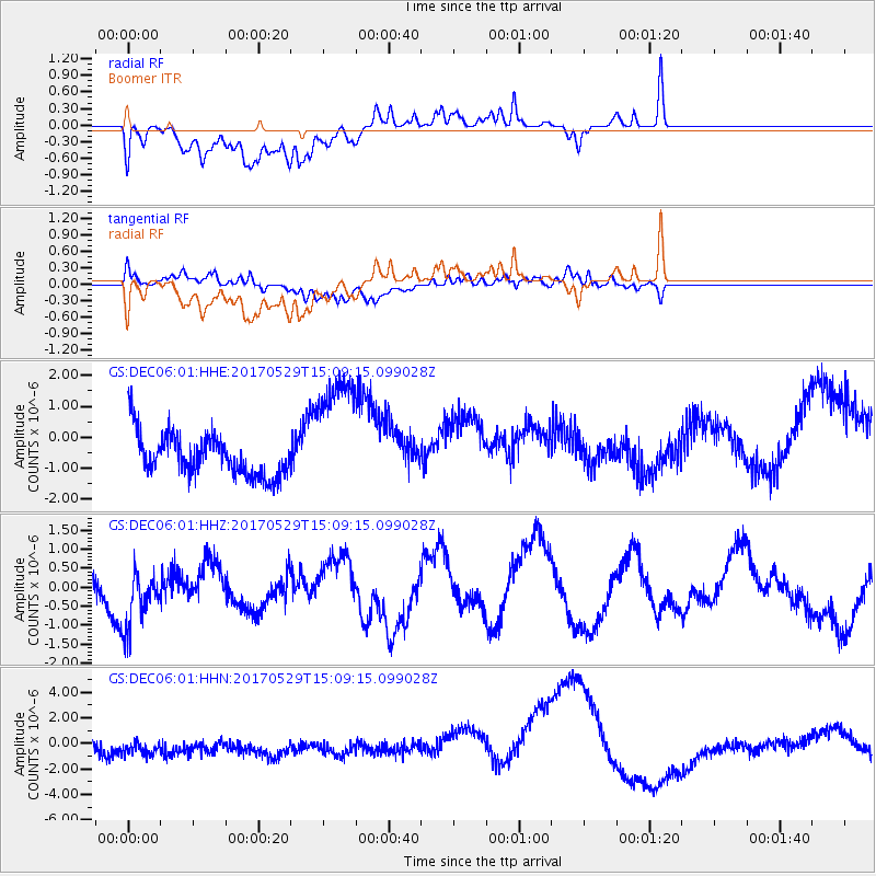
DEC06 Boomer - Earthquake Result Viewer
*The percent match for this event was below the threshold and hence no stack was calculated.
| Earthquake location: |
S. Chile-Argentina Border Region |
| Earthquake latitude/longitude: |
-37.3/-71.6 |
| Earthquake time(UTC): |
2017/05/29 (149) 14:57:54 GMT |
| Earthquake Depth: |
87 km |
| Earthquake Magnitude: |
5.7 Mwr |
| Earthquake Catalog/Contributor: |
NEIC PDE/us |
|
| Network: |
GS US Geological Survey Networks |
| Station: |
DEC06 Boomer |
| Lat/Lon: |
39.90 N/88.95 W |
| Elevation: |
215 m |
|
| Distance: |
78.5 deg |
| Az: |
346.477 deg |
| Baz: |
165.982 deg |
| Ray Param: |
$rayparam |
*The percent match for this event was below the threshold and hence was not used in the summary stack. |
|
| Radial Match: |
52.260323 % |
| Radial Bump: |
400 |
| Transverse Match: |
75.31665 % |
| Transverse Bump: |
400 |
| SOD ConfigId: |
2028011 |
| Insert Time: |
2017-06-12 15:06:12.080 +0000 |
| GWidth: |
2.5 |
| Max Bumps: |
400 |
| Tol: |
0.001 |
|
Signal To Noise
| Channel | StoN | STA | LTA |
| GS:DEC06:01:HHZ:20170529T15:09:15.099028Z | 1.4842016 | 7.674714E-7 | 5.170938E-7 |
| GS:DEC06:01:HHN:20170529T15:09:15.099028Z | 1.535774 | 1.4546208E-6 | 9.471581E-7 |
| GS:DEC06:01:HHE:20170529T15:09:15.099028Z | 3.008192 | 2.049107E-6 | 6.8117566E-7 |
| Arrivals |
| Ps | |
| PpPs | |
| PsPs/PpSs | |


