You are here: Home > Network List > TS - TERRAscope (Southern California Seismic Network) Stations List
> Station SBC Santa Barbara, California, USA > Earthquake Result Viewer
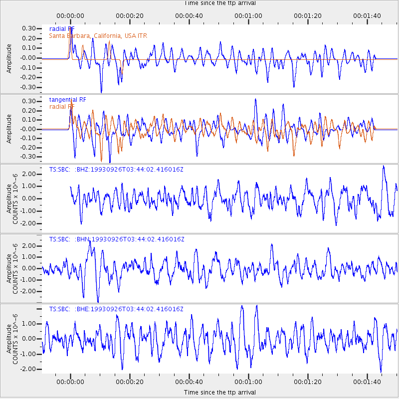
SBC Santa Barbara, California, USA - Earthquake Result Viewer
*The percent match for this event was below the threshold and hence no stack was calculated.
| Earthquake location: |
W. Caroline Islands, Micronesia |
| Earthquake latitude/longitude: |
10.0/138.2 |
| Earthquake time(UTC): |
1993/09/26 (269) 03:31:18 GMT |
| Earthquake Depth: |
33 km |
| Earthquake Magnitude: |
6.1 MB, 6.0 MS, 5.9 UNKNOWN, 6.4 MW |
| Earthquake Catalog/Contributor: |
WHDF/NEIC |
|
| Network: |
TS TERRAscope (Southern California Seismic Network) |
| Station: |
SBC Santa Barbara, California, USA |
| Lat/Lon: |
34.44 N/119.71 W |
| Elevation: |
90 m |
|
| Distance: |
94.2 deg |
| Az: |
54.118 deg |
| Baz: |
285.055 deg |
| Ray Param: |
$rayparam |
*The percent match for this event was below the threshold and hence was not used in the summary stack. |
|
| Radial Match: |
72.855 % |
| Radial Bump: |
400 |
| Transverse Match: |
69.62579 % |
| Transverse Bump: |
400 |
| SOD ConfigId: |
4480 |
| Insert Time: |
2010-02-26 14:49:40.929 +0000 |
| GWidth: |
2.5 |
| Max Bumps: |
400 |
| Tol: |
0.001 |
|
Signal To Noise
| Channel | StoN | STA | LTA |
| TS:SBC: :BHN:19930926T03:44:02.416016Z | 2.9675796 | 8.828352E-7 | 2.9749336E-7 |
| TS:SBC: :BHE:19930926T03:44:02.416016Z | 0.85696316 | 4.996925E-7 | 5.830968E-7 |
| TS:SBC: :BHZ:19930926T03:44:02.416016Z | 0.8615968 | 5.3607977E-7 | 6.2219334E-7 |
| Arrivals |
| Ps | |
| PpPs | |
| PsPs/PpSs | |


