You are here: Home > Network List > TA - USArray Transportable Network (new EarthScope stations) Stations List
> Station I30M Mount Dempster, Yukon, CAN > Earthquake Result Viewer
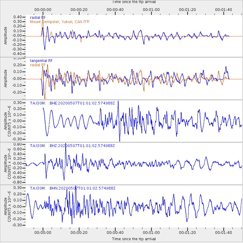
I30M Mount Dempster, Yukon, CAN - Earthquake Result Viewer
*The percent match for this event was below the threshold and hence no stack was calculated.
| Earthquake location: |
Northern Peru |
| Earthquake latitude/longitude: |
-5.7/-76.7 |
| Earthquake time(UTC): |
2020/05/07 (128) 00:49:10 GMT |
| Earthquake Depth: |
24 km |
| Earthquake Magnitude: |
5.3 Mww |
| Earthquake Catalog/Contributor: |
NEIC PDE/us |
|
| Network: |
TA USArray Transportable Network (new EarthScope stations) |
| Station: |
I30M Mount Dempster, Yukon, CAN |
| Lat/Lon: |
65.22 N/136.38 W |
| Elevation: |
1399 m |
|
| Distance: |
83.0 deg |
| Az: |
338.507 deg |
| Baz: |
120.105 deg |
| Ray Param: |
$rayparam |
*The percent match for this event was below the threshold and hence was not used in the summary stack. |
|
| Radial Match: |
70.3672 % |
| Radial Bump: |
400 |
| Transverse Match: |
63.125183 % |
| Transverse Bump: |
400 |
| SOD ConfigId: |
21166931 |
| Insert Time: |
2020-05-21 01:03:35.977 +0000 |
| GWidth: |
2.5 |
| Max Bumps: |
400 |
| Tol: |
0.001 |
|
Signal To Noise
| Channel | StoN | STA | LTA |
| TA:I30M: :BHZ:20200507T01:01:02.574988Z | 1.7783457 | 2.0500674E-7 | 1.1527946E-7 |
| TA:I30M: :BHN:20200507T01:01:02.574988Z | 0.54481274 | 6.1011036E-8 | 1.1198534E-7 |
| TA:I30M: :BHE:20200507T01:01:02.574988Z | 0.84632134 | 8.261977E-8 | 9.762223E-8 |
| Arrivals |
| Ps | |
| PpPs | |
| PsPs/PpSs | |


