You are here: Home > Network List > US - United States National Seismic Network Stations List
> Station DGMT Dagmar, Montana, USA > Earthquake Result Viewer
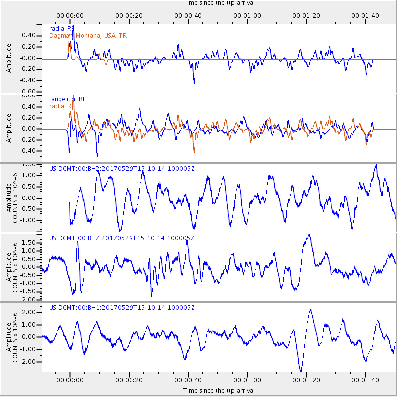
DGMT Dagmar, Montana, USA - Earthquake Result Viewer
*The percent match for this event was below the threshold and hence no stack was calculated.
| Earthquake location: |
S. Chile-Argentina Border Region |
| Earthquake latitude/longitude: |
-37.3/-71.6 |
| Earthquake time(UTC): |
2017/05/29 (149) 14:57:54 GMT |
| Earthquake Depth: |
87 km |
| Earthquake Magnitude: |
5.7 Mwr |
| Earthquake Catalog/Contributor: |
NEIC PDE/us |
|
| Network: |
US United States National Seismic Network |
| Station: |
DGMT Dagmar, Montana, USA |
| Lat/Lon: |
48.47 N/104.20 W |
| Elevation: |
0.0 m |
|
| Distance: |
90.2 deg |
| Az: |
339.002 deg |
| Baz: |
154.589 deg |
| Ray Param: |
$rayparam |
*The percent match for this event was below the threshold and hence was not used in the summary stack. |
|
| Radial Match: |
53.12332 % |
| Radial Bump: |
313 |
| Transverse Match: |
62.630352 % |
| Transverse Bump: |
400 |
| SOD ConfigId: |
2028011 |
| Insert Time: |
2017-06-12 15:08:46.958 +0000 |
| GWidth: |
2.5 |
| Max Bumps: |
400 |
| Tol: |
0.001 |
|
Signal To Noise
| Channel | StoN | STA | LTA |
| US:DGMT:00:BHZ:20170529T15:10:14.100005Z | 2.6925204 | 1.1054548E-6 | 4.1056506E-7 |
| US:DGMT:00:BH1:20170529T15:10:14.100005Z | 1.1919453 | 7.9588483E-7 | 6.677193E-7 |
| US:DGMT:00:BH2:20170529T15:10:14.100005Z | 0.56858975 | 4.2143176E-7 | 7.411878E-7 |
| Arrivals |
| Ps | |
| PpPs | |
| PsPs/PpSs | |


