You are here: Home > Network List > TA - USArray Transportable Network (new EarthScope stations) Stations List
> Station D27M Malcolm River, YT, CAN > Earthquake Result Viewer
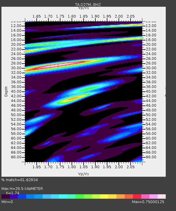
D27M Malcolm River, YT, CAN - Earthquake Result Viewer
| Earthquake location: |
Solomon Islands |
| Earthquake latitude/longitude: |
-4.5/154.7 |
| Earthquake time(UTC): |
2020/05/07 (128) 11:21:19 GMT |
| Earthquake Depth: |
466 km |
| Earthquake Magnitude: |
6.1 Mww |
| Earthquake Catalog/Contributor: |
NEIC PDE/us |
|
| Network: |
TA USArray Transportable Network (new EarthScope stations) |
| Station: |
D27M Malcolm River, YT, CAN |
| Lat/Lon: |
69.24 N/140.96 W |
| Elevation: |
896 m |
|
| Distance: |
85.3 deg |
| Az: |
18.806 deg |
| Baz: |
244.368 deg |
| Ray Param: |
0.043591384 |
| Estimated Moho Depth: |
28.5 km |
| Estimated Crust Vp/Vs: |
1.74 |
| Assumed Crust Vp: |
6.522 km/s |
| Estimated Crust Vs: |
3.748 km/s |
| Estimated Crust Poisson's Ratio: |
0.25 |
|
| Radial Match: |
81.62934 % |
| Radial Bump: |
400 |
| Transverse Match: |
62.434654 % |
| Transverse Bump: |
400 |
| SOD ConfigId: |
21166931 |
| Insert Time: |
2020-05-21 11:33:32.176 +0000 |
| GWidth: |
2.5 |
| Max Bumps: |
400 |
| Tol: |
0.001 |
|

Signal To Noise
| Channel | StoN | STA | LTA |
| TA:D27M: :BHZ:20200507T11:32:35.299999Z | 6.044389 | 4.141509E-7 | 6.851824E-8 |
| TA:D27M: :BHN:20200507T11:32:35.299999Z | 1.3374797 | 6.969841E-8 | 5.211175E-8 |
| TA:D27M: :BHE:20200507T11:32:35.299999Z | 3.2751365 | 8.116774E-8 | 2.478301E-8 |
| Arrivals |
| Ps | 3.3 SECOND |
| PpPs | 12 SECOND |
| PsPs/PpSs | 15 SECOND |


