You are here: Home > Network List > TA - USArray Transportable Network (new EarthScope stations) Stations List
> Station E20K Nigu River, AK, USA > Earthquake Result Viewer
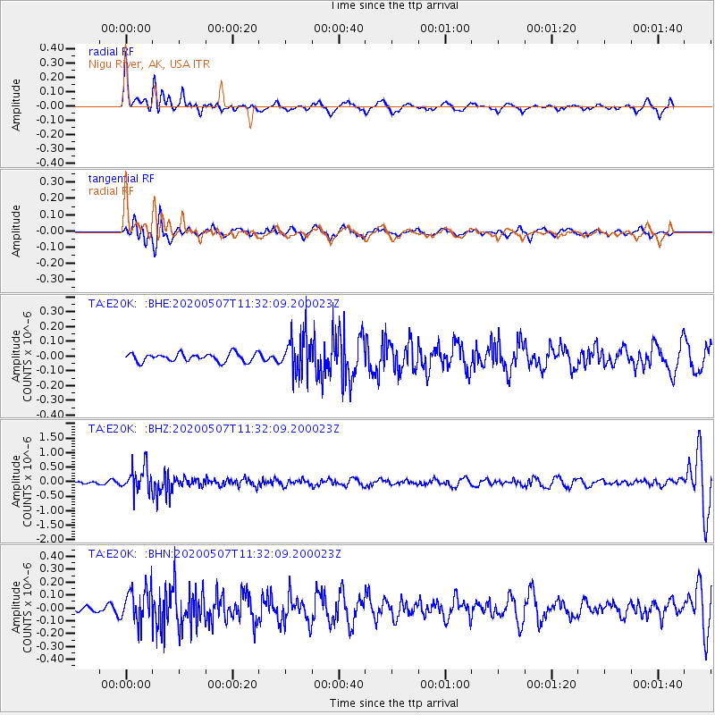
E20K Nigu River, AK, USA - Earthquake Result Viewer
*The percent match for this event was below the threshold and hence no stack was calculated.
| Earthquake location: |
Solomon Islands |
| Earthquake latitude/longitude: |
-4.5/154.7 |
| Earthquake time(UTC): |
2020/05/07 (128) 11:21:19 GMT |
| Earthquake Depth: |
466 km |
| Earthquake Magnitude: |
6.1 Mww |
| Earthquake Catalog/Contributor: |
NEIC PDE/us |
|
| Network: |
TA USArray Transportable Network (new EarthScope stations) |
| Station: |
E20K Nigu River, AK, USA |
| Lat/Lon: |
68.26 N/156.19 W |
| Elevation: |
866 m |
|
| Distance: |
80.1 deg |
| Az: |
16.61 deg |
| Baz: |
229.901 deg |
| Ray Param: |
$rayparam |
*The percent match for this event was below the threshold and hence was not used in the summary stack. |
|
| Radial Match: |
73.31494 % |
| Radial Bump: |
399 |
| Transverse Match: |
52.143112 % |
| Transverse Bump: |
400 |
| SOD ConfigId: |
21166931 |
| Insert Time: |
2020-05-21 11:33:37.488 +0000 |
| GWidth: |
2.5 |
| Max Bumps: |
400 |
| Tol: |
0.001 |
|
Signal To Noise
| Channel | StoN | STA | LTA |
| TA:E20K: :BHZ:20200507T11:32:09.200023Z | 10.3214 | 4.4457855E-7 | 4.3073474E-8 |
| TA:E20K: :BHN:20200507T11:32:09.200023Z | 2.2635858 | 1.349004E-7 | 5.9595887E-8 |
| TA:E20K: :BHE:20200507T11:32:09.200023Z | 4.8230743 | 1.3391963E-7 | 2.7766443E-8 |
| Arrivals |
| Ps | |
| PpPs | |
| PsPs/PpSs | |


