You are here: Home > Network List > TS - TERRAscope (Southern California Seismic Network) Stations List
> Station SBC Santa Barbara, California, USA > Earthquake Result Viewer
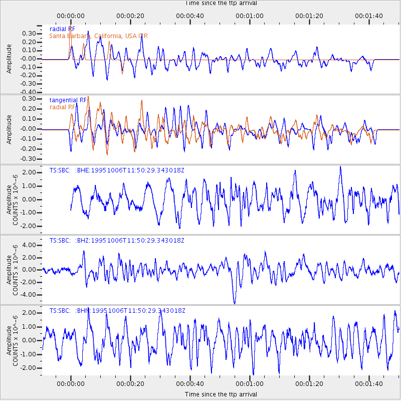
SBC Santa Barbara, California, USA - Earthquake Result Viewer
*The percent match for this event was below the threshold and hence no stack was calculated.
| Earthquake location: |
Tonga Islands |
| Earthquake latitude/longitude: |
-20.0/-175.9 |
| Earthquake time(UTC): |
1995/10/06 (279) 11:39:36 GMT |
| Earthquake Depth: |
209 km |
| Earthquake Magnitude: |
5.7 MB, 6.4 UNKNOWN, 6.3 MW |
| Earthquake Catalog/Contributor: |
WHDF/NEIC |
|
| Network: |
TS TERRAscope (Southern California Seismic Network) |
| Station: |
SBC Santa Barbara, California, USA |
| Lat/Lon: |
34.44 N/119.71 W |
| Elevation: |
90 m |
|
| Distance: |
76.1 deg |
| Az: |
45.043 deg |
| Baz: |
233.621 deg |
| Ray Param: |
$rayparam |
*The percent match for this event was below the threshold and hence was not used in the summary stack. |
|
| Radial Match: |
68.385254 % |
| Radial Bump: |
386 |
| Transverse Match: |
47.420887 % |
| Transverse Bump: |
345 |
| SOD ConfigId: |
4480 |
| Insert Time: |
2010-02-26 14:49:47.675 +0000 |
| GWidth: |
2.5 |
| Max Bumps: |
400 |
| Tol: |
0.001 |
|
Signal To Noise
| Channel | StoN | STA | LTA |
| TS:SBC: :BHZ:19951006T11:50:29.343018Z | 3.8739734 | 1.0756577E-6 | 2.7766265E-7 |
| TS:SBC: :BHN:19951006T11:50:29.343018Z | 1.6368508 | 9.2260126E-7 | 5.636441E-7 |
| TS:SBC: :BHE:19951006T11:50:29.343018Z | 1.9642819 | 1.1702978E-6 | 5.957891E-7 |
| Arrivals |
| Ps | |
| PpPs | |
| PsPs/PpSs | |


