You are here: Home > Network List > TA - USArray Transportable Network (new EarthScope stations) Stations List
> Station G31M Satah River, YT, CAN > Earthquake Result Viewer
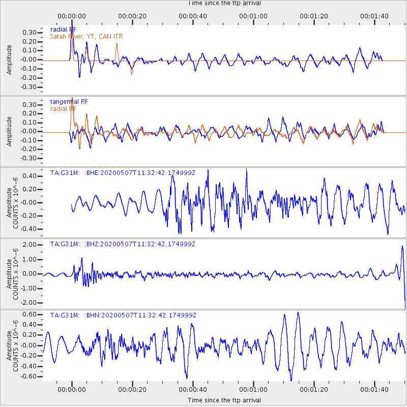
G31M Satah River, YT, CAN - Earthquake Result Viewer
*The percent match for this event was below the threshold and hence no stack was calculated.
| Earthquake location: |
Solomon Islands |
| Earthquake latitude/longitude: |
-4.5/154.7 |
| Earthquake time(UTC): |
2020/05/07 (128) 11:21:19 GMT |
| Earthquake Depth: |
466 km |
| Earthquake Magnitude: |
6.1 Mww |
| Earthquake Catalog/Contributor: |
NEIC PDE/us |
|
| Network: |
TA USArray Transportable Network (new EarthScope stations) |
| Station: |
G31M Satah River, YT, CAN |
| Lat/Lon: |
66.92 N/134.27 W |
| Elevation: |
61 m |
|
| Distance: |
86.7 deg |
| Az: |
21.924 deg |
| Baz: |
250.791 deg |
| Ray Param: |
$rayparam |
*The percent match for this event was below the threshold and hence was not used in the summary stack. |
|
| Radial Match: |
63.578804 % |
| Radial Bump: |
400 |
| Transverse Match: |
29.750774 % |
| Transverse Bump: |
371 |
| SOD ConfigId: |
21166931 |
| Insert Time: |
2020-05-21 11:34:25.652 +0000 |
| GWidth: |
2.5 |
| Max Bumps: |
400 |
| Tol: |
0.001 |
|
Signal To Noise
| Channel | StoN | STA | LTA |
| TA:G31M: :BHZ:20200507T11:32:42.174999Z | 4.980185 | 4.5356248E-7 | 9.1073424E-8 |
| TA:G31M: :BHN:20200507T11:32:42.174999Z | 0.8420722 | 1.03962506E-7 | 1.2346032E-7 |
| TA:G31M: :BHE:20200507T11:32:42.174999Z | 2.772204 | 2.238931E-7 | 8.076357E-8 |
| Arrivals |
| Ps | |
| PpPs | |
| PsPs/PpSs | |


