You are here: Home > Network List > TA - USArray Transportable Network (new EarthScope stations) Stations List
> Station I17K Unalakleet, AK, USA > Earthquake Result Viewer
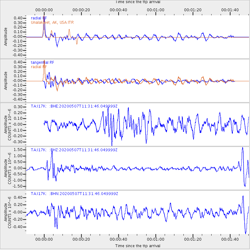
I17K Unalakleet, AK, USA - Earthquake Result Viewer
*The percent match for this event was below the threshold and hence no stack was calculated.
| Earthquake location: |
Solomon Islands |
| Earthquake latitude/longitude: |
-4.5/154.7 |
| Earthquake time(UTC): |
2020/05/07 (128) 11:21:19 GMT |
| Earthquake Depth: |
466 km |
| Earthquake Magnitude: |
6.1 Mww |
| Earthquake Catalog/Contributor: |
NEIC PDE/us |
|
| Network: |
TA USArray Transportable Network (new EarthScope stations) |
| Station: |
I17K Unalakleet, AK, USA |
| Lat/Lon: |
63.89 N/160.70 W |
| Elevation: |
105 m |
|
| Distance: |
75.8 deg |
| Az: |
18.691 deg |
| Baz: |
226.218 deg |
| Ray Param: |
$rayparam |
*The percent match for this event was below the threshold and hence was not used in the summary stack. |
|
| Radial Match: |
77.16143 % |
| Radial Bump: |
400 |
| Transverse Match: |
65.814064 % |
| Transverse Bump: |
400 |
| SOD ConfigId: |
21166931 |
| Insert Time: |
2020-05-21 11:34:35.695 +0000 |
| GWidth: |
2.5 |
| Max Bumps: |
400 |
| Tol: |
0.001 |
|
Signal To Noise
| Channel | StoN | STA | LTA |
| TA:I17K: :BHZ:20200507T11:31:46.049999Z | 5.9016485 | 5.522276E-7 | 9.357176E-8 |
| TA:I17K: :BHN:20200507T11:31:46.049999Z | 1.1280359 | 1.0219757E-7 | 9.05978E-8 |
| TA:I17K: :BHE:20200507T11:31:46.049999Z | 2.7414784 | 1.3204075E-7 | 4.8164072E-8 |
| Arrivals |
| Ps | |
| PpPs | |
| PsPs/PpSs | |


