You are here: Home > Network List > TA - USArray Transportable Network (new EarthScope stations) Stations List
> Station K15K Wolf Creek Mountain, AK, USA > Earthquake Result Viewer
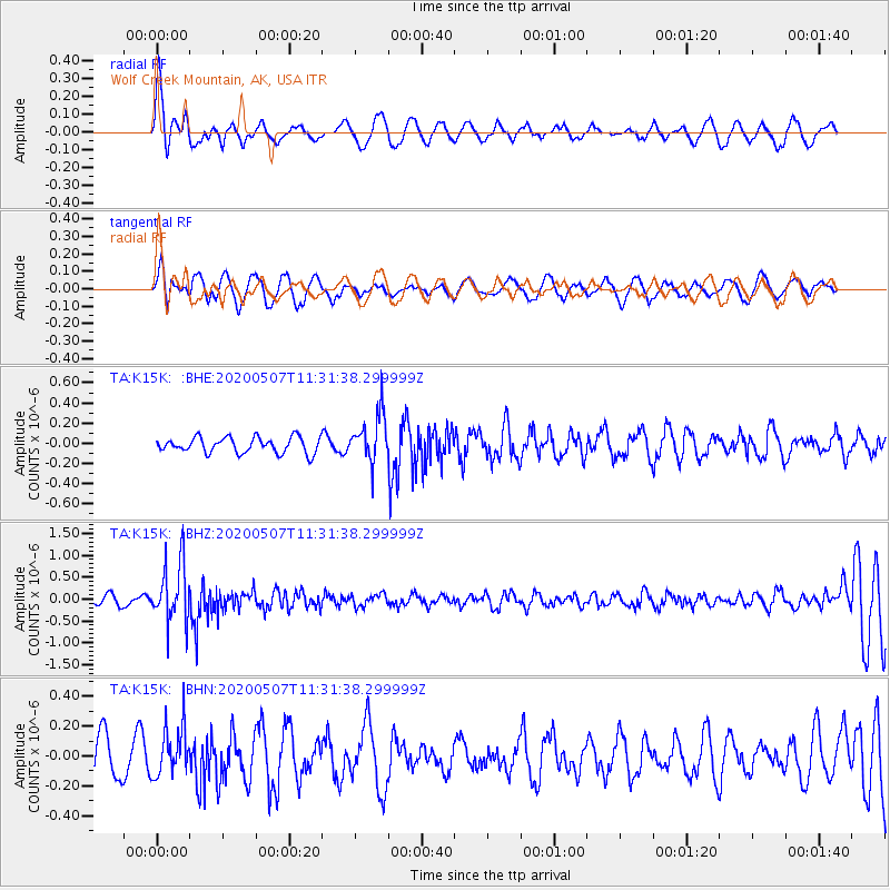
K15K Wolf Creek Mountain, AK, USA - Earthquake Result Viewer
*The percent match for this event was below the threshold and hence no stack was calculated.
| Earthquake location: |
Solomon Islands |
| Earthquake latitude/longitude: |
-4.5/154.7 |
| Earthquake time(UTC): |
2020/05/07 (128) 11:21:19 GMT |
| Earthquake Depth: |
466 km |
| Earthquake Magnitude: |
6.1 Mww |
| Earthquake Catalog/Contributor: |
NEIC PDE/us |
|
| Network: |
TA USArray Transportable Network (new EarthScope stations) |
| Station: |
K15K Wolf Creek Mountain, AK, USA |
| Lat/Lon: |
62.29 N/161.53 W |
| Elevation: |
346 m |
|
| Distance: |
74.4 deg |
| Az: |
19.606 deg |
| Baz: |
225.708 deg |
| Ray Param: |
$rayparam |
*The percent match for this event was below the threshold and hence was not used in the summary stack. |
|
| Radial Match: |
71.68023 % |
| Radial Bump: |
400 |
| Transverse Match: |
54.168415 % |
| Transverse Bump: |
400 |
| SOD ConfigId: |
21166931 |
| Insert Time: |
2020-05-21 11:34:48.149 +0000 |
| GWidth: |
2.5 |
| Max Bumps: |
400 |
| Tol: |
0.001 |
|
Signal To Noise
| Channel | StoN | STA | LTA |
| TA:K15K: :BHZ:20200507T11:31:38.299999Z | 7.5934405 | 6.856365E-7 | 9.029326E-8 |
| TA:K15K: :BHN:20200507T11:31:38.299999Z | 1.1108785 | 1.6279563E-7 | 1.4654674E-7 |
| TA:K15K: :BHE:20200507T11:31:38.299999Z | 3.1385784 | 2.3938128E-7 | 7.62706E-8 |
| Arrivals |
| Ps | |
| PpPs | |
| PsPs/PpSs | |


