You are here: Home > Network List > TA - USArray Transportable Network (new EarthScope stations) Stations List
> Station O17K Koliganek, Bristol Bay, AK, USA > Earthquake Result Viewer
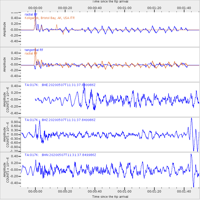
O17K Koliganek, Bristol Bay, AK, USA - Earthquake Result Viewer
*The percent match for this event was below the threshold and hence no stack was calculated.
| Earthquake location: |
Solomon Islands |
| Earthquake latitude/longitude: |
-4.5/154.7 |
| Earthquake time(UTC): |
2020/05/07 (128) 11:21:19 GMT |
| Earthquake Depth: |
466 km |
| Earthquake Magnitude: |
6.1 Mww |
| Earthquake Catalog/Contributor: |
NEIC PDE/us |
|
| Network: |
TA USArray Transportable Network (new EarthScope stations) |
| Station: |
O17K Koliganek, Bristol Bay, AK, USA |
| Lat/Lon: |
59.77 N/157.09 W |
| Elevation: |
156 m |
|
| Distance: |
74.4 deg |
| Az: |
23.057 deg |
| Baz: |
230.514 deg |
| Ray Param: |
$rayparam |
*The percent match for this event was below the threshold and hence was not used in the summary stack. |
|
| Radial Match: |
73.349304 % |
| Radial Bump: |
324 |
| Transverse Match: |
40.337738 % |
| Transverse Bump: |
392 |
| SOD ConfigId: |
21166931 |
| Insert Time: |
2020-05-21 11:35:25.896 +0000 |
| GWidth: |
2.5 |
| Max Bumps: |
400 |
| Tol: |
0.001 |
|
Signal To Noise
| Channel | StoN | STA | LTA |
| TA:O17K: :BHZ:20200507T11:31:37.849986Z | 3.8988748 | 4.1297517E-7 | 1.05921636E-7 |
| TA:O17K: :BHN:20200507T11:31:37.849986Z | 1.3133037 | 1.1780961E-7 | 8.970478E-8 |
| TA:O17K: :BHE:20200507T11:31:37.849986Z | 2.8748329 | 1.9282629E-7 | 6.707391E-8 |
| Arrivals |
| Ps | |
| PpPs | |
| PsPs/PpSs | |


