You are here: Home > Network List > TX - Texas Seismological Network Stations List
> Station WTFS Witchita Falls > Earthquake Result Viewer
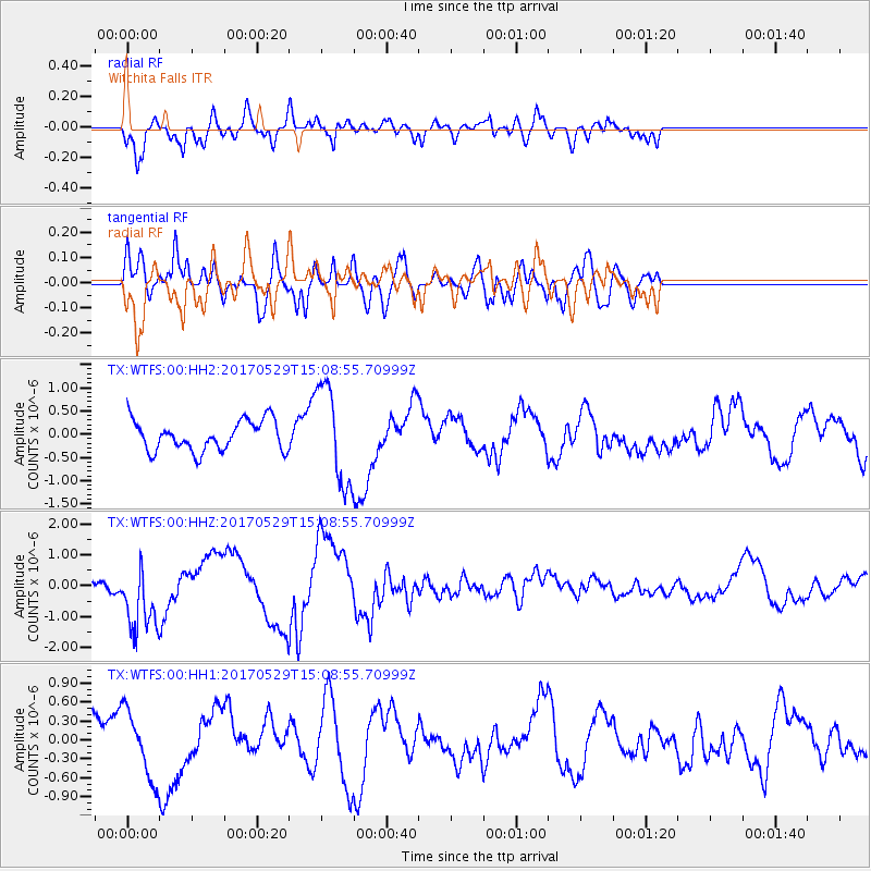
WTFS Witchita Falls - Earthquake Result Viewer
*The percent match for this event was below the threshold and hence no stack was calculated.
| Earthquake location: |
S. Chile-Argentina Border Region |
| Earthquake latitude/longitude: |
-37.3/-71.6 |
| Earthquake time(UTC): |
2017/05/29 (149) 14:57:54 GMT |
| Earthquake Depth: |
87 km |
| Earthquake Magnitude: |
5.7 Mwr |
| Earthquake Catalog/Contributor: |
NEIC PDE/us |
|
| Network: |
TX Texas Seismological Network |
| Station: |
WTFS Witchita Falls |
| Lat/Lon: |
33.77 N/98.46 W |
| Elevation: |
277 m |
|
| Distance: |
75.0 deg |
| Az: |
337.083 deg |
| Baz: |
158.128 deg |
| Ray Param: |
$rayparam |
*The percent match for this event was below the threshold and hence was not used in the summary stack. |
|
| Radial Match: |
64.154655 % |
| Radial Bump: |
400 |
| Transverse Match: |
53.914948 % |
| Transverse Bump: |
400 |
| SOD ConfigId: |
2028011 |
| Insert Time: |
2017-06-12 15:10:45.168 +0000 |
| GWidth: |
2.5 |
| Max Bumps: |
400 |
| Tol: |
0.001 |
|
Signal To Noise
| Channel | StoN | STA | LTA |
| TX:WTFS:00:HHZ:20170529T15:08:55.70999Z | 1.7502037 | 1.0346847E-6 | 5.911796E-7 |
| TX:WTFS:00:HH1:20170529T15:08:55.70999Z | 2.0291173 | 5.3144174E-7 | 2.6190784E-7 |
| TX:WTFS:00:HH2:20170529T15:08:55.70999Z | 3.2224762 | 1.0518813E-6 | 3.2642018E-7 |
| Arrivals |
| Ps | |
| PpPs | |
| PsPs/PpSs | |


